

Favourite
Allemans-du-Dropt frescoes
| Municipality | Thénac |
|---|---|
| Postcode | 24240 |
| Latitude | 44.7500349 (N 44° 45’ 0”) |
| Longitude | 0.3411070 (E 0° 20’ 28”) |
| Altitude | From 75m to 191m |
| Surface area | 20.34 km² |
| Population | 485 inhabitants |
| Density | 23 inhabitants/km² |
| Prefecture | Périgueux (77 km, 1:16) |
| Insee code | 24549 |
| Intercommunality | CA Bergeracoise |
| Department | Dordogne |
| Territories | Aquitaine, Périgord |
| Region | New-Aquitaine |
| Monestier | 4.6 km (9 min) |
|---|---|
| Cunèges | 5.6 km (12 min) |
| Sigoulès-et-Flaugeac | 5.8 km (11 min) |
| Loubès-Bernac | 7.4 km (12 min) |
| Gageac-et-Rouillac | 8.1 km (18 min) |
| Mescoules | 9.1 km (17 min) |
| Pomport | 9.2 km (17 min) |
| Saint-Julien-Innocence-Eulalie | 9.2 km (16 min) |
| Soumensac | 9.5 km (19 min) |
| Fonroque | 10.3 km (18 min) |
| Saussignac | 10.4 km (14 min) |
| Saint-Astier | 10.4 km (15 min) |
| Razac-de-Saussignac | 10.5 km (16 min) |
| Singleyrac | 11.6 km (19 min) |
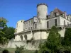
| Monuments |
|---|
| Last name | Activity type | Rate | City |
|---|---|---|---|
 | Nature and the great outdoors | 10 € to 60 € | Port-Sainte-Foy-et-Ponchapt (14.7 km) |
 | Sports sensations | 12 € to 20 € | Pessac-sur-Dordogne (22 km) |
 | Entertainment | 49 € | Monclar (37 km) |
 | Sports sensations | 80 € to 225 € | La Réole (37 km) |
 | Local flavours | Free | Saint-Médard-de-Guizières (43 km) |
| Last name | Outing type | Difficulty | Duration | Departure municipality |
|---|---|---|---|---|
 | Hike | Easy | 3:00 | Villebramar (27 km) |
 | Hike | Intermediate | 1:45 | Tombeboeuf (28 km) |
 | Hike | Easy | 2:30 | Bossugan (31 km) |
 | Hike | Athletic | 4:15 | Cancon (33 km) |
 | Hike | Easy | 1:00 | Beaumontois en Périgord (34 km) |