The seaside resort of Pléneuf-Val-André is located not far from the municipalities of Lamballe and Saint-Brieuc, in the Côtes-d'Armor.
In an exceptional natural setting, Pléneuf-Val-André is distinguished by the plurality of its sites:
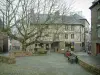
Pléneuf, a town created in the 5th century by refugees from Great Britain, is today the administrative center of the town.
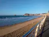
Le Val-André, a seaside resort created from scratch in 1880 by Charles Cotard, has retained all the charm of its villas on the seafront, made of pink sandstone, ocher schist and decorated with ornate white wood balustrades. Many leisure activities, shops and restaurants await you there, in addition of course to the beach.
Dahouët, the former home port of the Terre-neuvas has retained all the charm of the 19th century which saw it prosper. Now converted into yachting, it is made up of a floating dock and a stranding port, which together offer 498 berths.
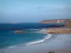
These three sites are bordered by four fine sandy beaches (Ville Berneuf beach, Nantois beach, Vallées beach, and Val André beach). The largest spreads out its fine sand over 2.5 km, along a promenade dike. The Verdelet rock, an ornithological reserve, completes this landscape and is accessible at high tides.
Finally, the GR34 allows you to follow the coast, alternating beaches and cliffs, for unforgettable hikes. The great outdoors are available to you: immense sea, islets, sheer cliffs on long sandy stretches...

")