Liven up your holidays!

Villecomtal-sur-Arros

Tourism, holidays & weekends guide in the Gers

This former stronghold of the Middle Ages, with an area of ​​1117 hectares for an altitude of 176 m, received a charter of customs in 1337.

At the crossroads of major communication routes, the RN 21 can be considered the backbone of this city.

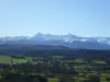
As its name implies, the town is situated in the valley of the Arros, many in the hollow wooded hills of oak forest, on a scenic route from the Pyrenees to the Gers. You can admire a magnificent view of the Pyrenees up the coast Laguian-Mazous.

Various businesses and enterprises (dairy, precision engineering, plastic molding, laser cutting / water jet, building, masonry ...).

Geographical information

MunicipalityVillecomtal-sur-Arros
Postcode32730
Latitude43.4013500 (N 43° 24’ 5”)
Longitude0.1980080 (E 0° 11’ 53”)
AltitudeFrom 168m to 315m
Surface area11.17 km²
Population857 inhabitants
Density76 inhabitants/km²
PrefectureAuch (49 km, 47 min)
Insee code32464
IntercommunalityCC Astarac Arros en Gascogne
DepartmentGers
TerritoriesGascony, Midi-Pyrénées
RegionOccitanie

Nearest cities & towns

Betplan2 km (4 min)
Rabastens-de-Bigorre4.2 km (5 min)
Montégut-Arros4.4 km (7 min)
Malabat4.6 km (7 min)
Haget4.7 km (8 min)
Mingot5.8 km (10 min)
Beccas5.9 km (8 min)
Sarriac-Bigorre6.6 km (8 min)
Fréchède6.6 km (10 min)
Sénac6.8 km (10 min)
Saint-Sever-de-Rustan6.8 km (7 min)
Laguian-Mazous7 km (8 min)
Moumoulous7.1 km (9 min)
Cazaux-Villecomtal7.7 km (13 min)

Things to see and do

The village has an old fortified gate, pointed barrel vault. Note large fragments of the same wall in two houses of the town.

The 19th century church has within it a series of five paintings Chavanty and nice paintings on the ceiling inside.

There are still only vestiges of the past history of Villecomtal the door of the Castle Arcourt, in the heart of the old village, near some old houses with tiled roofs and red ocher.

Events and festivities

The communal feast held on the last weed end-July.

Photos

A landscape of winter 1961
See photo

Weather

Thursday 25 april
Min. 7°C - Max. 15°C
Day
Night
Friday 26 april
Min. 5°C - Max. 17°C
Day
Night
Saturday 27 april
Min. 8°C - Max. 19°C
Day
Night

Visits, leisure and activities nearby

Leisure activities

Last nameActivity typeRateCity
N'co Park treetop adventure park
Sports sensations15 € to 25 € Lannemezan (37 km)
Caving in Hautes-Pyrénées
Sports sensations39 € to 70 € Bagnères-de-Bigorre (38 km)
Guided tour with an accredited guide
Culture and education200 € to 350 € Lourdes (40 km)
Cliff climbing lessons for all abilities
Sports sensations45 € Campan (43 km)
Whitewater rafting
Sports sensations35 € Navailles-Angos (44 km)

Outings

Last nameOuting typeDifficultyDurationDeparture municipality
Chemin de Toulicou
HikeEasy2:00Ossun (30 km)
Bazian-Riguepeu over the fields
HikeEasy2:30Bazian (31 km)
Lake Aignan
HikeEasy1:40Aignan (34 km)
Discovery of the campan valley a velo
All-terrain bike itineraryEasy1:00Bagnères-de-Bigorre (37 km)
The baronies by the asque couret
Cycling itineraryIntermediate3:45Bagnères-de-Bigorre (38 km)

Restaurants

Bed & breakfasts

Vacation rentals

Campsites

Hotels

Your holidays
A hotel
A vacation rental
A bed & breakfast
A campsite
A leisure activity
A restaurant
A rental car
A plane ticket
By continuing to browse our site, you are agreeing to the use of cookies to improve your experience and make targeted offers.
Find out more and make settings
Your account