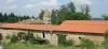
- Castle (Cultural Center)
- Table d'orientation
- Wash houses, bread ovens


Favourite
| Municipality | Valprivas |
|---|---|
| Postcode | 43210 |
| Latitude | 45.3116940 (N 45° 18’ 42”) |
| Longitude | 4.0456390 (E 4° 2’ 44”) |
| Altitude | From 491m to 953m |
| Surface area | 23.66 km² |
| Population | 539 inhabitants |
| Density | 22 inhabitants/km² |
| Prefecture | Le Puy-en-Velay (58 km, 59 min) |
| Insee code | 43249 |
| Intercommunality | CC Marches du Velay-Rochebaron |
| Department | Haute-Loire |
| Territories | Auvergne, Massif Central |
| Region | Auvergne-Rhône-Alps |
| Saint-Hilaire-Cusson-la-Valmitte | 7.6 km (12 min) |
|---|---|
| Merle-Leignec | 9.5 km (13 min) |
| Bas-en-Basset | 10 km (13 min) |
| Apinac | 12.7 km (18 min) |
| Saint-Pal-de-Chalencon | 13 km (18 min) |
| Boisset | 14 km (20 min) |
| Saint-Nizier-de-Fornas | 14 km (25 min) |
| Rozier-Côtes-d'Aurec | 14.4 km (20 min) |
| Estivareilles | 15 km (22 min) |
| Tiranges | 16.5 km (23 min) |
| Beauzac | 16.5 km (22 min) |
| La Tourette | 17 km (28 min) |
| Saint-Bonnet-le-Château | 17.1 km (25 min) |
| Monistrol-sur-Loire | 17.5 km (23 min) |
Circuit path
| Last name | Activity type | Rate | City |
|---|---|---|---|
 | Entertainment | 30 € | Tence (29 km) |
| Last name | Outing type | Difficulty | Duration | Departure municipality |
|---|---|---|---|---|
 | Hike | Easy | 45 min | Retournac (12.1 km) |
 | Hike | Intermediate | 3:10 | Montarcher (16.9 km) |
 | Car itinerary | Easy | 2:00 | Vorey (17.5 km) |
 | Hike | Intermediate | 3:30 | Saillant (19.1 km) |
 | Hike | Easy | 1:30 | Yssingeaux (19.8 km) |