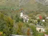
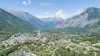
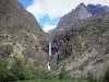
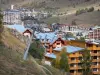
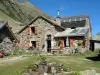
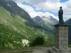
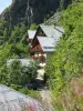
The Valjouffrey is a hiker's paradise with the refuge Font Turbat, Valsenestre village and other villages. It has many hiking departures.
Favourite


The Valjouffrey is a hiker's paradise with the refuge Font Turbat, Valsenestre village and other villages. It has many hiking departures.
| Municipality | Valjouffrey |
|---|---|
| Postcode | 38740 |
| Latitude | 44.8730556 (N 44° 52’ 23”) |
| Longitude | 6.0319444 (E 6° 1’ 55”) |
| Altitude | From 923m to 3565m |
| Surface area | 127.55 km² |
| Population | 144 inhabitants |
| Density | 1 inhabitants/km² |
| Prefecture | Grenoble (85 km, 1:15) |
| Insee code | 38522 |
| Intercommunality | CC de la Matheysine |
| Department | Isère |
| Territories | Alps, Dauphiné |
| Region | Auvergne-Rhône-Alps |
| Entraigues | 9 km (14 min) |
|---|---|
| Valbonnais | 13 km (18 min) |
| Siévoz | 19.5 km (26 min) |
| Chantepérier | 19.9 km (27 min) |
| Saint-Michel-en-Beaumont | 22 km (35 min) |
| Saint-Laurent-en-Beaumont | 24 km (34 min) |
| Sainte-Luce | 25 km (38 min) |
| Oris-en-Rattier | 25 km (34 min) |
| La Salle-en-Beaumont | 26 km (34 min) |
| Quet-en-Beaumont | 30 km (40 min) |
| Les Côtes-de-Corps | 34 km (43 min) |
| Corps | 38 km (47 min) |
| Aspres-lès-Corps | 42 km (49 min) |
| La Salette-Fallavaux | 43 km (51 min) |
The association "pouring Memory" offers cultural activities and is working on an eco-museum on the old sawmill.
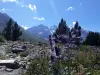
Activities: Hiking, climbing.
| Natural sites |
|---|
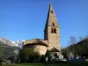
Village fete (often in the Chalp Valjouffrey) but also Valsenestre.
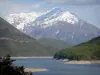
The walk is the major activity on this huge common, but it can also be climbing. Water sports are practiced in the valley below, at the commune of Valbonne.
Between Gap and Grenoble: water sports Sautet. At the foot of the village of body, just before the Sautet dam, the water sports welcomes you in an authentic nature ideal for ... Boat cruise electro-solar electric boat rental without a license, pedal boats, swimming area supervised in July and August, free parking, refreshments. Through the gorges of the Souloise two circuits at the bottom of the gorge PD (1:30) and AD (2:30) with bridge over the Drac. Via induction: two easy routes between 20 min and 45 min, for beginners and children from 1, 10 m. Rental of material through on-site in July and August.
| Last name | Activity type | Rate | City |
|---|---|---|---|
 | Culture and education | 585 € | Villar-d'Arêne (30 km) |
 | Nature and the great outdoors | 200 € to 1100 € | Ancelle (31 km) |
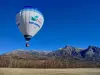
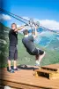 | Sports sensations | 30 € | L'Argentière-la-Bessée (43 km) |
 | Sports sensations | 50 € to 80 € | Grenoble (43 km) |
 | Sports sensations | 50 € to 65 € | Grenoble (43 km) |
| Last name | Outing type | Difficulty | Duration | Departure municipality |
|---|---|---|---|---|
 | Hike | Athletic | 4:35 | Saint-Christophe-en-Oisans (14 km) |
 | Hike | Intermediate | 2:30 | Saint-Christophe-en-Oisans (14 km) |
 | Hike | Athletic | 1:45 | Saint-Christophe-en-Oisans (14.4 km) |
 | Hike | Easy | 55 min | Saint-Christophe-en-Oisans (14.9 km) |
 | Hike | Intermediate | 3:15 | Saint-Christophe-en-Oisans (14.9 km) |