Trèves is a commune in the Gard department, in the Occitanie region, 28 km east of La Cavalerie.
Vast 26 km², bordering to the south and west of the department of Aveyron, its territory oscillates from 514 to 1298 m in altitude, falling within the natural region of the Cévennes.
The locality is crossed from east to west by the course of the Trévézel which forms gorges deep in the causses. The river then flows into the Dourbie, also in the town.
Trèves is divided into different sectors with varied reliefs and landscapes: the Causses Noir and Bégon, respectively on the right (north) and left (south) banks of the Trévezel, dominated by passes and peaks close to 1000 m in altitude, but also the plateau of Canayère to the northeast, overlooked by Montmal (1266 m) and the Cévennes, to the southeast, at the foot of the rock of Saint-Guiral.
Between causses and summits, the town has preserved a green environment, covered with forests (46% of its area), natural herbaceous or shrubby environments (43%) and meadows.
The town developed in the Middle Ages on the right bank of the Trévezel, possession of the Roquefeuil family, and under the reign of Charles V (14th century), people enjoyed the right to move around and trade freely, which boosted economic activity (woodworking, hemp industry). Later, mines were exploited in Villemagne, to the north.
Nowadays, the village has only 110 inhabitants, but it has retained a picturesque appearance and tourism thrives there in season thanks to an exceptional natural heritage that delights hiking enthusiasts.
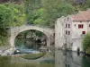
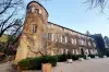
The village with its narrow streets still offers a medieval face of character. In terms of heritage, in addition to the Notre-Dame-de-la-Purification church, built in a Romanesque style in the 13th century, the most notable element is the Old Bridge, also known as Roman Bridge. A first bridge was built in Roman antiquity, which was carried away by a flood of the Trévezel in the 13th century. The bases of the pillars were preserved during the reconstruction that followed. Now listed in the Inventory, the work is made up of three semicircular arches, and two piers have sharp spurs. The roadway, for its part, forms a speed bump between two parapets. At the level of the large pile, a stone cross is erected, probably dating from the beginning of the 17th century.
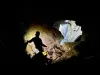
Also worth mentioning are caves occupied since - 3500 (twin caves of Baume Lairoux and Grotte de la Verrière), as well as the Grotte du Pas de Joulié which served as a necropolis for our distant ancestors.
A 6th century cross, old stone fountains and finally the Fort de la Baume (13th century) can also be observed during a tour devoted to historical heritage.
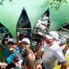
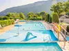
In terms of leisure, it is allowed to swim in the refreshing waters of the Trévezel (at the village level), before discovering its gorges… Trout fishing enthusiasts will also find their account there.
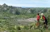
Still, it is mainly for its hiking trails (for walkers or mountain bikers) that the locality delights holidaymakers.
Several natural sites (gorges, passes) are accessible via marked trails. These may present some difficulties, which are less present for those who prefer simply to follow paths on the causses dedicated to pastoralism (sheep farming).
The Rocher du regard which overlooks the village, the Caïla orientation table, the granite or dolomitic cliffs also give rise to beautiful walks.
Also note that the interpretive trail "Le Causse de Canayère" is synonymous with geological and historical time travel. The different stops allow you to understand the influence of man on his environment and on the landscape, and its evolution in the recent past, in particular the passage of open agricultural and inhabited environments (hamlets, cultivation terraces, mills, lime) to woodlands over the past 150 years. Viewpoints punctuate the journey. Departure from the Forest House of Canayère near the RD 710. Two possible circuits, 1.9 or 3.4 km. Information from the Cévennes National Park on +33 4 66 49 53 00. Same number for activities (workshops, exhibitions) offered by the Park throughout the year.
For all other hikes, but also the practice of canyoning, maps and information on +33 4 66 36 96 30.
On the cultural side, finally, the village is distinguished by its areas dedicated to "Land Art" (artistic creation using natural environments, especially plants) along the river. Information from the Filature du Mazel (which also operates on Mont Aigoual) on +33 7 88 61 42 63 or +33 4 67 68 24 07.