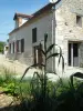
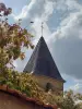
Village whose authenticity has remained intact, with a very dense forest fabric.


Favourite
Village whose authenticity has remained intact, with a very dense forest fabric.
| Municipality | Stigny |
|---|---|
| Postcode | 89160 |
| Latitude | 47.7739450 (N 47° 46’ 26”) |
| Longitude | 4.2337080 (E 4° 14’ 1”) |
| Altitude | From 208m to 328m |
| Surface area | 17.86 km² |
| Population | 93 inhabitants |
| Density | 5 inhabitants/km² |
| Prefecture | Auxerre (60 km, 1:03) |
| Insee code | 89403 |
| Intercommunality | CC Le Tonnerrois en Bourgogne |
| Department | Yonne |
| Territory | Burgundy |
| Region | Burgundy-Franche-Comté |
| Chassignelles | 5.5 km (10 min) |
|---|---|
| Ravières | 5.7 km (11 min) |
| Jully | 5.7 km (10 min) |
| Ancy-le-Franc | 6.2 km (10 min) |
| Gland | 6.5 km (10 min) |
| Sennevoy-le-Bas | 6.9 km (11 min) |
| Nuits | 7.1 km (12 min) |
| Sennevoy-le-Haut | 7.6 km (11 min) |
| Gigny | 8 km (11 min) |
| Fulvy | 8.5 km (15 min) |
| Asnières-en-Montagne | 10.6 km (17 min) |
| Pimelles | 10.7 km (16 min) |
| Verdonnet | 10.9 km (17 min) |
| Cry | 11.6 km (18 min) |
| Last name | Activity type | Rate | City |
|---|---|---|---|
 | Entertainment | 30 € to 40 € | Ville-sur-Arce (40 km) |
| Last name | Outing type | Difficulty | Duration | Departure municipality |
|---|---|---|---|---|
 | Hike | Intermediate | 5:20 | Étourvy (22 km) |
 | All-terrain bike itinerary | Athletic | 5:40 | Mussy-sur-Seine (30 km) |
 | Hike | Easy | 3:25 | Courteron (32 km) |
 | All-terrain bike itinerary | Easy | 5:15 | Chaource (32 km) |
 | Hike | Easy | 2:00 | Courgis (36 km) |