Visit the old Saint Nicolas lead-argentifer mine (in summer).
Walk the mine trail. Easy ride and modulable in duration.
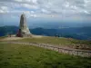
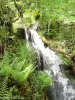
See the beautiful Erzenbach waterfall, an hour's ride, without difficulty.


| Municipality | Steinbach |
|---|---|
| Postcode | 68700 |
| Latitude | 47.8217510 (N 47° 49’ 18”) |
| Longitude | 7.1525060 (E 7° 9’ 9”) |
| Altitude | From 309m to 922m |
| Surface area | 6.09 km² |
| Population | 1379 inhabitants |
| Density | 226 inhabitants/km² |
| Prefecture | Colmar (39 km, 38 min) |
| Insee code | 68322 |
| Intercommunality | CC de Thann-Cernay |
| Department | Haut-Rhin |
| Territory | Alsace |
| Region | Great East |
| Uffholtz | 2.6 km (6 min) |
|---|---|
| Cernay | 2.8 km (7 min) |
| Vieux-Thann | 4.8 km (7 min) |
| Wattwiller | 5.3 km (10 min) |
| Thann | 7.3 km (14 min) |
| Aspach-le-Bas | 8.3 km (13 min) |
| Wittelsheim | 8.3 km (14 min) |
| Aspach-Michelbach | 8.8 km (13 min) |
| Leimbach | 8.9 km (15 min) |
| Berrwiller | 9 km (14 min) |
| Roderen | 9.8 km (16 min) |
| Staffelfelden | 10.1 km (16 min) |
| Wuenheim | 10.6 km (17 min) |
| Bitschwiller-lès-Thann | 11 km (19 min) |
Visit the old Saint Nicolas lead-argentifer mine (in summer).
Walk the mine trail. Easy ride and modulable in duration.
See the beautiful Erzenbach waterfall, an hour's ride, without difficulty.


| Last name | Activity type | Rate | City |
|---|---|---|---|
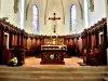
 | Culture and education | 11 € | Le Thillot (30 km) |
 | Culture and education | 6 € to 8 € | Labaroche (32 km) |
 | Entertainment | Free | Xonrupt-Longemer (34 km) |
 | Arts and Crafts | 12 € | Basse-sur-le-Rupt (35 km) |
 | Local flavours | Free | Rodern (47 km) |
| Last name | Outing type | Difficulty | Duration | Departure municipality |
|---|---|---|---|---|
 | Hike | Intermediate | 1:05 | Thann (3.8 km) |
 | Hike | Intermediate | 1:00 | Burnhaupt-le-Haut (10.2 km) |
 | Hike | Intermediate | 3:00 | Masevaux-Niederbruck (12.7 km) |
 | Hike | Intermediate | 3:00 | Ranspach (12.8 km) |
 | Village visit | Easy | 1:00 | Masevaux-Niederbruck (12.8 km) |