Liven up your holidays!

Soulce-Cernay

Tourism, holidays & weekends guide in the Doubs

Soulce-Cernay - Tourism, holidays & weekends guide in the Doubs
8.8
7

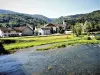
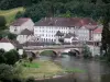
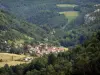
Commune in the Doubs valley, its name originates from the salt spring and salt wells, probably operated from Roman times until the 17th century (the water went on fagots and salt is recovered crystallized). The Doubs River contributes to the planning and development of the village EDF dam, fishing and aquaculture, farm house, renovated deck.

Geographical information

MunicipalitySoulce-Cernay
Postcode25190
Latitude47.3249120 (N 47° 19’ 30”)
Longitude6.8589240 (E 6° 51’ 32”)
AltitudeFrom 377m to 850m
Surface area8.55 km²
Population134 inhabitants
Density15 inhabitants/km²
PrefectureBesançon (99 km, 1:15)
Insee code25551
IntercommunalityCC du Pays de Maîche
DepartmentDoubs
TerritoriesFranche-Comté, Jura mountains
RegionBurgundy-Franche-Comté

Nearest cities & towns

Saint-Hippolyte4 km (6 min)
Montjoie-le-Château5.8 km (9 min)
Vaufrey7.3 km (11 min)
Bief8.7 km (12 min)
Liebvillers9.9 km (15 min)
Courtefontaine10.5 km (15 min)
Chamesol11.5 km (20 min)
Noirefontaine11.5 km (13 min)
Villars-sous-Dampjoux11.6 km (14 min)
Montécheroux11.7 km (20 min)
Les Plains-et-Grands-Essarts11.8 km (17 min)
Fleurey12 km (21 min)
Dampjoux12.4 km (15 min)
Les Terres-de-Chaux13 km (19 min)

Things to see and do

Hiking.

Canoeing in the summer.

Photos

Soulce-Cernay, seen from the bridge over the Doubs (© J.E)
See photo
Fountain of Soulce-Cernay (© J.E)
See photo
St. Lawrence Church (© J.E)
See photo
The Doubs, upstream of the bridge (© J.E)
See photo
Facade of the Town Hall (© J.E)
See photo
Salted well - Hamlet of Saulnerie (© J.E)
See photo
Porch of the resurgence of the Basset (left), and porch of the cave of the castle of the rock, seen from the Saint-Hippolyte-Vaufrey road (© J.E)
See photo
Soulce
Soulce
See photo
The Doubs
The Doubs
See photo
St. Lawrence Church (© J.E)
See photo
Salted well - Hamlet of Saulnerie (© J.E)
See photo
Salted well - Hamlet of Saulnerie (© J.E)
See photo
Porch of the cave of the castle of the rock (© J.E)
See photo
Porch of the Basset Resurgence (© J.E)
See photo
Armoried Boundary Limit of the Castle of the Rock (© J.E)
See photo
Armoried Boundary Limit of the Castle of the Rock (© J.E)
See photo
Memorial panel to Joël Journot (© J.E)
See photo
Elbow to the west, from the bottom of the cave of the castle of the rock (© J.E)
See photo
Interior of the cave of the castle of the rock (© J.E)
See photo
Porch of the cave of the castle of the rock, seen from the bottom (© J.E)
See photo
Porch of the cave of the castle of the rock (© J.E)
See photo
Porch of the cave of the castle of the rock, seen from the bottom (© J.E)
See photo
Porch of the cave, seen from the bottom (© J.E)
See photo
Porch of the cave of the castle of the rock (© J.E)
See photo
Rest of the access gate to the castle of the rock (© J.E)
See photo
Rest of the walls of the castle of the rock (© J.E)
See photo
Ruins, in height, of the walls of the castle of the rock (© J.E)
See photo

Weather

Wednesday 24 april
Min. -2°C - Max. 4°C
Day
Night
Thursday 25 april
Min. 0°C - Max. 7°C
Day
Night
Friday 26 april
Min. 1°C - Max. 10°C
Day
Night

Visits, leisure and activities nearby

Outings

Last nameOuting typeDifficultyDurationDeparture municipality
Walk to Fort Lachaux- Grand-Charmont, Sochaux, Montbéliard
HikeIntermediate35 minGrand-Charmont (22 km)
Reposoir Chapel
HikeEasy1:00Pays-de-Clerval (28 km)
Ban Forest
HikeIntermediate35 minHauterive-la-Fresse (50 km)
Rangen massif
HikeIntermediate1:00Burnhaupt-le-Haut (50 km)
Tour of the historic centre
Village visitEasy1:00Masevaux-Niederbruck (51 km)

Restaurants

Bed & breakfasts

Vacation rentals

Campsites

Hotels

Your holidays
A hotel
A vacation rental
A bed & breakfast
A campsite
A leisure activity
A restaurant
A rental car
A plane ticket
By continuing to browse our site, you are agreeing to the use of cookies to improve your experience and make targeted offers.
Find out more and make settings
Your account