Liven up your holidays!

Savournon

Tourism, holidays & weekends guide in the Hautes-Alpes

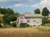
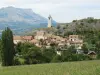
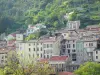
This charming little village, enjoying a sunny climate, is at the trough of the Val de Channe and is part of the canton of Serres in the Hautes-Alpes and Provence-Alpes-Cote d'Azur.

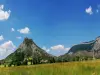
Situated 753 meters above sea level and crowned by the peaks of Aujour (1824 m), Revuaire (1302 m) and Aranbre (1434 m), neighboring municipalities and the Bersac The Built-Montsaléon.

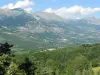
Savournon lies between the Alps and Provence, near the axis Marseille - Grenoble, 42 km from Gap which is located in the northeast and 36 km from Sisteron which is located to the southwest.

Geographical information

MunicipalitySavournon
Postcode05700
Latitude44.4218339 (N 44° 25’ 19”)
Longitude5.7942000 (E 5° 47’ 39”)
AltitudeFrom 671m to 1760m
Surface area39.23 km²
Population254 inhabitants
Density6 inhabitants/km²
PrefectureGap (42 km, 42 min)
Insee code05165
IntercommunalityCC du Sisteronais-Buëch
DepartmentHautes-Alpes
TerritoriesAlps, Dauphiné
RegionProvence-Alps-French Riviera

Nearest cities & towns

Le Bersac4 km (6 min)
La Bâtie-Montsaléon6.7 km (11 min)
Chabestan8.1 km (13 min)
Montrond8.6 km (12 min)
Serres9.1 km (13 min)
Méreuil9.7 km (17 min)
Le Saix11.3 km (18 min)
Oze12.3 km (19 min)
Montclus12.4 km (16 min)
Sigottier12.7 km (18 min)
Garde-Colombe13.5 km (15 min)
Ventavon14.5 km (24 min)
Saint-Auban-d'Oze15.1 km (24 min)
Saléon15.4 km (20 min)

Things to see and do

Remains of the castle of the Eagle.

Bodies of water (swimming, fishing).

Jubéo forest.

Hiking, biking and riding.

Places of interest

Natural sites

Photos

Village Savournon
Village Savournon
See photo

Weather

Thursday 25 april
Min. 0°C - Max. 12°C
Day
Night
Friday 26 april
Min. 4°C - Max. 8°C
Day
Night
Saturday 27 april
Min. 6°C - Max. 13°C
Day
Night

Visits, leisure and activities nearby

Leisure activities

Last nameActivity typeRateCity
Donkey trek in Hautes Alpes
Nature and the great outdoors50 € to 375 € Éourres (25 km)
Easy ceramics class
Arts and Crafts30 € Saint-Vincent-sur-Jabron (28 km)
Visit a saffron and red fruit farm
Local flavoursFreeNoyers-sur-Jabron (29 km)
Hot air balloon flight over the Champsaur Valley
Nature and the great outdoors200 € to 1100 € Ancelle (40 km)
Electric mountain bike ride with a guide
Sports sensations60 € to 375 € Saint-Étienne-les-Orgues (42 km)

Outings

Last nameOuting typeDifficultyDurationDeparture municipality
Marmites du Diable loop
HikeIntermediate2:15La Faurie (16.7 km)
From Montfroc to Les Omergues
HikeEasy1:00Montfroc (33 km)
Notre-Dame du Laus
HikeIntermediate5:00La Bâtie-Vieille (33 km)
La Bâtie-Vieille - Rambaud
HikeEasy3:00La Bâtie-Vieille (33 km)
The white bridge trail
HikeEasy3:00Saint-Laurent-du-Cros (35 km)

Restaurants

Bed & breakfasts

Vacation rentals

Campsites

Hotels

Your holidays
A hotel
A vacation rental
A bed & breakfast
A campsite
A leisure activity
A restaurant
A rental car
A plane ticket
By continuing to browse our site, you are agreeing to the use of cookies to improve your experience and make targeted offers.
Find out more and make settings
Your account