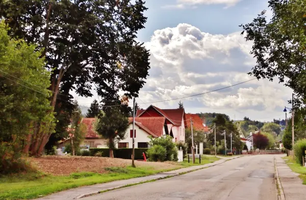
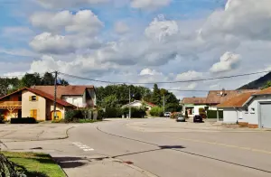
Saulcy-sur-Meurthe is a commune in the Vosges department, in the Grand Est region, a few kilometers south-east of Saint-Dié-des-Vosges which it borders.
Its territory of 16 km² oscillates from 359 to 740 m in altitude, including to the west the Kemberg massif, whose highest point is the Roche d'Anozel.
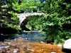
Crossed from south to north by the Meurthe, but also its tributaries the Anoux and the Mandray, the locality has retained a green environment, mainly covered with forests (46% of its area) and meadows dedicated to livestock farming (25%). The only communal forest is vast of 218 hectares, but nearly half of this wealth was impacted during the storm of December 1999.
The village developed in the Middle Ages, shared between several seigniories and depending in particular on the chapter of Saint-Die. The inhabitants have long lived from agriculture and the exploitation of woods and forests. In the 20th century, however, Saulcy-sur-Meurthe, which had already suffered from the First World War, was devastated at the end of the Second World War. There are only three houses left in the town and 325 families out of 400 in the town at the time are homeless.
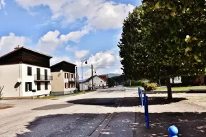
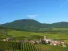
Rebuilt, the village and its hamlets now feature unspoiled landscapes and nature and a rich leisure offer. At the gates of Saint-Dié and near the Vosges resorts to the south (Gérardmer is 20 km away), Saulcy-sur-Meurthe (2,400 inhabitants) will seduce lovers of green tourism.
Despite the hardships endured during the two world wars, the locality has some elements of heritage that should be observed.
The oldest is located at the foot of the Kemberg massif, to the west of the town: it is a copper mine which was exploited in the Middle Ages and then reached its peak in the 16th century. Now abandoned, it testifies to a singular past, and its surroundings, secured, are now highlighted and punctuate a walk.
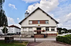
Then in the village, if nothing remains of the feudal castle dynamited in 1944 by the German armies before their retreat, the seminary housed in the park was rehabilitated by the Boussac company then acquired by the town. This elegant building has been partly transformed into housing and also houses municipal premises (including the old chapel).
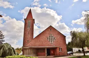
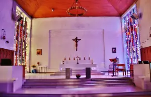
Also worth seeing is the parish church of Saint-Jean-Baptiste: rebuilt in a neo-Byzantine style in 1711, it was destroyed in November 1944 due to the fire at an ammunition depot located nearby. A new building was rebuilt from 1962, worship taking place until then in a temporary chapel. The church was inaugurated in the fall of 1964. Combining reinforced concrete and bonded stone, it has a rectangular nave which opens onto an apse of the same shape. The complex is flanked to the north by a baptistery extended by the parish annexes and to the south by the sacristy. The entrance facade is dominated by a glass roof in shimmering colors in the shape of a cross made by the workshop of Gabriel Loire (Chartres). These same craftsmen designed the stained glass windows of the baptismal font, the nave and the choir. In addition, a stand was built, supported by concrete pillars. Contemporary but sober in style, the building designed by the Polish-born architect François Boleslas de Jankowski is surmounted by a 5-metre high wrought iron cross made in Rambervillers. Finally, we notice, in front of the church, a 13th century votive cross carved in sandstone and weighing almost 700 kilos: it is the only vestige of the previous building...
A stopover in Saulcy can finally understand, from memory requires, the visit of the national necropolis which shelters, in the south of the commune, 2565 bodies of French soldiers fallen in the area during the First war (of which 1174 were buried in two ossuaries), but also those of 11 Russians and from a Romanian. In addition, in addition to a monument, a plaque pays tribute to eight American soldiers killed in November 1944.
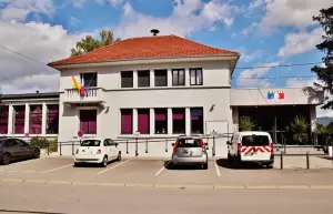
On the cultural side, activities are offered regularly at the library (information on +33 3 29 56 59 19) and shows and associative events are scheduled at the village hall (contact +33 3 29 52 45 35).
For sports enthusiasts, football pitches and tennis courts are accessible to visitors, as well as a fitness trail in the middle of nature. Located on Rue de l'Ancien Séminaire, 1.8 km long, it includes 12 pieces of equipment and was designed in a wooded setting.
A city stadium is available for the youngest.
It remains to take advantage of the potential offered on the territory in terms of hiking. A 3 km long marked route has been laid out on the slopes of the Kemberg, near the old Anozel mine. At the end of the course, a picnic area is located next to the Sainte-Anne fountain. Points of view mark out this journey. Other loops are possible to reach other wooded reliefs to the south, along the Cours de Meurthe or even reach Saint-Dié... Maps and information on +33 3 29 42 22 22.
The first Saturday in March, carnival.
Third Saturday in March, St. Patrick's Day.
At the end of June, on the occasion of Saint-Jean, fun fair and traditional conflagration.
The third Sunday of December, Christmas market.