Le Teilleul is a village in the Manche region of Normandy, on the borders of Orne, to the east, and Mayenne, to the south. The town is located 40 km southeast of Avranches and the Bay of Mont Saint-Michel.
Le Teilleul which counted until then 1 255 inhabitants merged in 2016 with the neighboring localities of Ferrières (52 inhabitants), Heussé (226 inhabitants), Husson (192 inhabitants) and Saint-Marie-du-Bois (52 inhabitants), now totaling nearly 1,800 inhabitants.
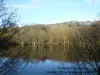
The vast territory of the new commune (66 km²) is made up of bocage landscapes, where agricultural activity predominates (breeding, orchards). A line of water divides through Le Teilleul: to the north, the many small rivers join the Sélune which flows into the Channel and to the south, they are tributaries of the Mayenne which itself joins the Loire to jump into the 'ocean.
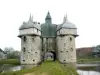
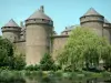
Former small fortified lordship from the tenth century, Le Teilleul is the victim of looting and fire in the twelfth during the conflicts between the Norman nobility to the King of England.
Under the Ancien Régime, the lands are divided between different fiefs held by lords whose castles are manhandled after the Revolution.
At the beginning of the twenty-first century, however, the town still has a heritage of interest, but it is above all its green environment near some major sites such as Mont-Saint-Michel, the Cotentin or the D-Day beaches that makes it a stage appreciated by lovers of green tourism.
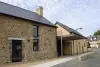
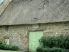
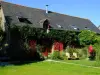
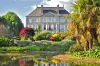
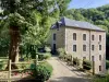
In terms of built heritage, Le Teilleul has on its territory many mansions often surrounded by farms and farmland and remains of castles.
At the main village, we will focus especially on the Saint-Patrice Church. The building is classified and its construction was completed in 1854. However, a first chapel had been built since the tenth century and a second church in the Middle Ages, was once a time of the Abbey of Savigny. Specialists relate the current church to the neo-Norman style in vogue in the nineteenth century. However, there is an amazing central belfry at the facade with side bells and a sacristy which affects a circular plan. The furniture and stained glass are also nineteenth. On the other hand, the imposing baptismal fonts with double vats, elaborated in granite and in wood, date from the 15th and 16th centuries.
In the old villages that merged, to see in Ferrières, the church Saint-Siméon the Stylite of the seventeenth century, and Heussé, the castle of Nantray (nineteenth) and the church of St. Peter (nineteenth).
In Husson, another church dedicated to Saint-Pierre, but of the 18th century, and the manor of Tavelière, are worth a look. Finally, Notre-Dame Church in Sainte-Marie-du-Bois is also worth a detour.
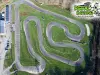
These different sites such as the many paths along the groves, small wooded parcels and streams can give rise to many hiking or mountain biking. To know the different possible circuits, documentation and information on +33 2 33 05 98 70 or +33 2 33 59 19 74.
Horseback riding and canoeing on some of the rivers are also possible. Information on +33 2 33 59 19 74.
At the village of Teilleul, a multi-sport hall, a tennis court and a bowling alley are accessible. Inquire at +33 2 33 59 40 05.
Finally, note that the media library regularly hosts quality exhibitions. Contact the +33 2 33 60 38 28.
In September, on the occasion of the Heritage Days, a concert with the Orchester de Normandie is organized in one of the churches of the town (Le Teilleul or Heussé).
Every month except in December, a large trade and craft fair brings together many exhibitors. The most popular takes place in April on the occasion of Saint-Georges (Thursday around April 23). Friendly and musical animations are organized in parallel.
In addition, every first Saturday of the month of April to October, a market of local products is held under the halls, place of the fairground. A unique opportunity to discover the wealth of products from the Normandy region (cured meats, dairy products, cider, etc.).
Balade Pédestre Mortainaise en Soirée
- On 23 july 2024
- Organized by the Mortain-Bocage Animations association. - 8:00 pm : hiking in Le Teilleul. Meeting point at the market square. Circuit between 7 and 9 km. Free admission. - Contact : Thérèse Desserouer 02/33/59/02/53 or 06/89/60/77/19.
Renaudies gardens, floral park at Colombiers du Plessis.
Amusement park in the Colmont Gorron. Adventure park, swin-golf, mini-rafting ...
Hiking the jump-to-wolf Brecé near Gorron. Interpretive trail around the heritage and nature. 7, 12, 13, 15, 20 km.