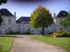
Possible picnic on harbor
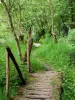
Footpaths
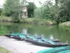
Rowing at the dock at the Autize
| Municipality | Saint-Sigismond |
|---|---|
| Postcode | 85420 |
| Latitude | 46.3493590 (N 46° 20’ 58”) |
| Longitude | -0.6890060 (W 0° 41’ 20”) |
| Altitude | From 1m to 11m |
| Surface area | 10.46 km² |
| Population | 428 inhabitants |
| Density | 40 inhabitants/km² |
| Prefecture | La Roche-sur-Yon (85 km, 1:04) |
| Insee code | 85269 |
| Intercommunality | CC Vendée, Sèvre, Autise |
| Department | Vendée |
| Territory | Poitou |
| Region | Pays de la Loire |
| Le Mazeau | 2.3 km (6 min) |
|---|---|
| Liez | 3 km (5 min) |
| Maillezais | 5.9 km (9 min) |
| Bouillé-Courdault | 6.4 km (10 min) |
| Damvix | 7.7 km (12 min) |
| Saint-Pierre-le-Vieux | 8.2 km (13 min) |
| Benet | 9.8 km (14 min) |
| Rives-d'Autise | 10.6 km (18 min) |
| Le Vanneau-Irleau | 10.8 km (22 min) |
| Arçais | 11.9 km (18 min) |
| Maillé | 12 km (17 min) |
| Doix lès Fontaines | 12.1 km (17 min) |
| Coulon | 14 km (18 min) |
| Saint-Martin-de-Fraigneau | 15.2 km (21 min) |
Possible picnic on harbor
Footpaths
Rowing at the dock at the Autize
| Last name | Activity type | Rate | City |
|---|---|---|---|
 | Nature and the great outdoors | 175 € to 1035 € | Sainte-Hermine (37 km) |
| Last name | Outing type | Difficulty | Duration | Departure municipality |
|---|---|---|---|---|
 | Hike | Intermediate | 3:45 | Saint-Michel-le-Cloucq (15.7 km) |
 | Hike | Easy | 1:05 | Le Gué-de-Velluire (18.2 km) |
 | Hike | Easy | 1:05 | La Taillée (18.8 km) |
 | Hike | Easy | 1:00 | La Taillée (18.8 km) |
 | Hike | Easy | 4:55 | Sainte-Radégonde-des-Noyers (28 km) |