Liven up your holidays!

Saint-Planchers

Tourism, holidays & weekends guide in the Manche

Saint-Planchers - Tourism, holidays & weekends guide in the Manche
8.0
3

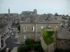
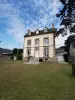
Located in grove, in the department of Manche in Basse-Normandie, Saint-Planchers is a charming little village that covers 1200 hectares. Located approximately 45 meters above sea level, the town has 54 hamlets, and in 1297 people since the 2009 census, it belongs to the canton of Granville and the district of Avranches. The inhabitants are called Pancraciens and Pancraciennes.

Three rivers flowing from north-east to south-west share a common two rows of rounded hills, interrupted by several small valleys cross. In the North, the town Boscq limit a distance of 1 km, the limit is Bleed all the southern and central Oiselière determines a central valley quite pronounced.

The names of hamlets and ancient face are many foreign Saint-Planchers as Filbec (Philbec or Filbecq) Celtic sounding (meaning beak stream), Le Theil (Teil) or Blackmar (Blaquemar) are Saxon names, and Fougeray The Vesquerie and Mesleraye (Melleray) are sounding Latin.

Thus, the common Saint-Planchers is full of memories of Mont-Saint-Michel. The church of the late eleventh-early 12th century priory Oiselière, wood and most fiefs belonged to the Archangel.

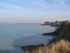
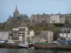
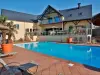
Mainly focused on agriculture, Saint-Planchers is the gateway to the sea, 10 km from the center of Granville also known as the Monaco of the North, and 40 km from Mont-Saint-Michel. The town is close to the Regional Natural Park of Cotentin and Bessin about 37 km. A beautiful life for the dynamic town with its many associations and new school site.

Geographically surrounded by the municipalities of Saint-Aubin-des-Préaux, Boscq Anctoville-sur-Saint-Pair-sur-Mer, Saint-Jean-des-Champs and Granville, Saint-Planchers part of the Community of Municipalities of Granville.

Geographical information

MunicipalitySaint-Planchers
Postcode50400
Latitude48.8250070 (N 48° 49’ 30”)
Longitude-1.5262020 (W 1° 31’ 34”)
AltitudeFrom 17m to 98m
Surface area11.96 km²
Population1471 inhabitants
Density122 inhabitants/km²
PrefectureSaint-Lô (70 km, 54 min)
Insee code50541
IntercommunalityCC de Granville, Terre et Mer
DepartmentManche
RegionNormandy

Nearest cities & towns

Saint-Aubin-des-Préaux3.2 km (6 min)
Anctoville-sur-Boscq3.6 km (7 min)
Yquelon5 km (9 min)
Saint-Pair-sur-Mer5.2 km (10 min)
Saint-Jean-des-Champs5.3 km (9 min)
Longueville5.3 km (7 min)
Bréville-sur-Mer6.6 km (11 min)
Hudimesnil6.6 km (10 min)
Donville-les-Bains6.7 km (11 min)
Granville7.5 km (13 min)
Saint-Pierre-Langers7.8 km (10 min)
Coudeville-sur-Mer7.8 km (9 min)
Saint-Sauveur-la-Pommeraye8.5 km (12 min)

Things to see and do

To see the altarpiece of the church which is classified.

Photos

Church (late eleventh-early 12th century)
See photo
Town Hall
Town Hall
See photo
Entrance to the common (D154)
See photo

Weather

Thursday 25 april
Min. 3°C - Max. 12°C
Day
Night
Friday 26 april
Min. 8°C - Max. 13°C
Day
Night
Saturday 27 april
Min. 9°C - Max. 12°C
Day
Night

Visits, leisure and activities nearby

Leisure activities

Last nameActivity typeRateCity
Rêver Réalité animal park
EntertainmentFreeChampeaux (8.7 km)
Flight over Mont Saint-Michel Bay on Ultralight Trike or Autogyro – 30 mins
Sports sensations140 € Le Val-Saint-Père (20 km)
Flight over Mont Saint-Michel Bay by Ultralight Trike or Autogyro – 20 mins
Sports sensations100 € Le Val-Saint-Père (20 km)
Visit an exhibition and sale at artists' studios
Arts and CraftsFreeDol-de-Bretagne (35 km)
Segway ride to explore Saint-Malo in a different way
Entertainment29 € to 168 € Saint-Malo (41 km)

Outings

Last nameOuting typeDifficultyDurationDeparture municipality
Crossing of Mont-Saint-Michel Bay
HikeIntermediate3:30Le Mont-Saint-Michel (21 km)
Gouville-sur-Mer cabins
HikeEasy1:00Gouville-sur-Mer (31 km)
Variant of GR 22 by Brécey
HikeEasy3:15Reffuveille (32 km)
Beach Bridge to the beach in Le Havre Lupin
HikeEasy2:00Saint-Malo (42 km)
Saint-Jacut's grand tour
HikeIntermediate5:35Saint-Jacut-de-la-Mer (55 km)

Restaurants

Bed & breakfasts

Vacation rentals

Campsites

Hotels

Your holidays
A hotel
A vacation rental
A bed & breakfast
A campsite
A leisure activity
A restaurant
A rental car
A plane ticket
By continuing to browse our site, you are agreeing to the use of cookies to improve your experience and make targeted offers.
Find out more and make settings
Your account