Saint-Nic is a coastal town in the department of Finistère, in the Brittany region, 20 km northeast of Douarnenez.
Its 18 km² territory is bordered to the west by the Atlantic Ocean, at the bay of Douarnenez, and marks the "southern" entrance to the Crozon peninsula.
Crossed by several streams which descend from the sides of the small mountain of Ménez Hom, to the northeast, and flow into the ocean, the locality takes the form of several "steps" and terraces which lead to the coast. This includes beaches and dunes to the south and cliffs to the north.
The village, for its part, developed on a plateau set back from the coast.
Always rural in character (arable land and agricultural areas make up 76% of its area), Saint-Nic, which has nearly 800 inhabitants, is now a pleasant seaside resort. It highlights its beaches and its preserved environment which appeal to holidaymakers and families looking for calm, while being close to major tourist sites (Crozon, Locronan, etc.).
In terms of heritage, several sites of interest are worth mentioning in the town.
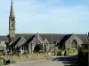
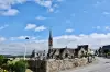
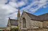
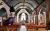
In addition to the dolmen of Ménez, dating from about 3000 years before our era, vestige of a funerary monument, it is the case of the parish church of Saint-Nicaise, erected in its current form in the 16th century (the date of 1566 is inscribed). Gothic in style, its nave is not symmetrical, with three bays with an aisle to the north, four bays with an aisle to the south, and the ceiling is paneled. In addition to the 23-meter high bell tower, we note the sandpits of the side porch, the decorations of which represent chimeras in particular, and include twelve niches dedicated to the apostles.
In addition to the Calvary and the sundial, in the enclosure, the church is renowned for housing two reliquaries from the 16th and 18th centuries, for its 16th century stained glass windows depicting the Passion and the Last Judgment and a number of statues (including a Polychrome Pieta by the Prigent brothers from the 16th century). The building is protected as a historical monument.
Next, see the Saint-Côme and Saint-Damien chapel, the oldest parts of which date back to the 15th century. The site was previously known to promote healing, and then remained a very popular place of pilgrimage for several centuries. A Gothic-style fountain can be seen away, and at the level of the chapel itself, on the framework in the shape of a boat's hull, the beams and sandpits with rich carved decorations (figuring monstrous characters). The gallery bell tower is also remarkable.
Finally, note again, the Saint-Jean chapel (16th century, restored in 1873) with its Gothic door, its flamboyant style bays and its enclosure comprising Calvary and fountain…
On the cultural side, activities are regularly offered at the library (inquire at +33 2 98 81 50 89) and shows and associative events are scheduled at the communal hall of Pentrez (information in town hall at +33 2 98 26 50 36).
As far as "nature" leisure and activities are concerned, the dunes garden is accessible in the small town, which includes playgrounds and picnic tables.
However, it is the beaches that legitimately attract holidaymakers.
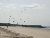
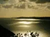
Those of Pentrez and La Lieue de Grève, on the southern half of the municipal coastline, constitute a 4 km long complex covered with fine sand. The site is monitored in July and August. Ideal for swimming, lazing around, kite flying and sand yachting (contact the local club on +33 6 11 80 09 79), these beaches are also popular with kitesurfing enthusiasts: a school offers initiations in season (info at +33 6 80 67 14 16). Contact details of the first aid station open in summer: +33 2 98 26 55 11.
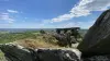
To the north, Caméros beach is sheltered from the winds due to the rocks that surround it and the cliff that dominates it. Paragliders can be observed there "flying over" the site...
For hikers, various marked trails are traced in the town, which notably connect the coast and the sides of the mountain, to the east, and which are marked heritage elements or protected natural sites. In addition, the GR34 which follows the coast (the famous "path of the customs officers") allows you to discover different aspects of the bay (cliffs to the north, sandy beaches and wetlands to the south). It joins Plomodiern to the south and the Crozon peninsula to the north. Maps and information on +33 2 98 26 55 15 (in July and August) and on +33 2 98 81 27 37 (the rest of the year).
It is also always possible to join the outings (course of 6 to 12 km) of the local club: join +33 6 61 80 73 76.