

Favourite
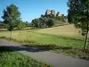
The Voie Verte greenway
| Municipality | Saint-Maurice-des-Champs |
|---|---|
| Postcode | 71460 |
| Latitude | 46.6290000 (N 46° 37’ 44”) |
| Longitude | 4.6219000 (E 4° 37’ 19”) |
| Altitude | From 275m to 408m |
| Surface area | 5.83 km² |
| Population | 63 inhabitants |
| Density | 10 inhabitants/km² |
| Prefecture | Mâcon (50 km, 54 min) |
| Insee code | 71461 |
| Intercommunality | CC Sud Côte Chalonnaise |
| Department | Saône-et-Loire |
| Territory | Burgundy |
| Region | Burgundy-Franche-Comté |
| Saint-Martin-du-Tartre | 2.4 km (6 min) |
|---|---|
| Vaux-en-Pré | 2.5 km (5 min) |
| Saint-Gengoux-le-National | 4.5 km (10 min) |
| Saint-Clément-sur-Guye | 5.1 km (11 min) |
| Burnand | 5.3 km (10 min) |
| Genouilly | 5.9 km (9 min) |
| Bissy-sur-Fley | 6.3 km (10 min) |
| Culles-les-Roches | 6.4 km (11 min) |
| Burzy | 6.6 km (16 min) |
| Joncy | 7.1 km (13 min) |
| Fley | 7.4 km (14 min) |
| Curtil-sous-Burnand | 7.5 km (15 min) |
| Sercy | 7.7 km (15 min) |
| Santilly | 8 km (15 min) |
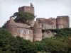
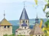
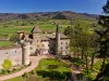
| Monuments |
|---|
| Last name | Activity type | Rate | City |
|---|---|---|---|
 | Sports sensations | 9 € to 20 € | Tournus (23 km) |
 | Sports sensations | 19 € | Saint-Marcel (27 km) |
 | Culture and education | 10 € | Saint-Point (32 km) |
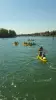
| Last name | Outing type | Difficulty | Duration | Departure municipality |
|---|---|---|---|---|
 | Hike | Easy | 2:00 | Saint-Martin-du-Tartre (1.6 km) |
 | Hike | Easy | 2:00 | Culles-les-Roches (3.3 km) |
 | Hike | Easy | 2:00 | Saint-Martin-sous-Montaigu (22 km) |
 | Hike | Easy | 2:00 | Saint-Martin-sous-Montaigu (22 km) |
| Hike | Easy | 5:00 | Tournus (23 km) |