


Favourite
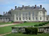
Craon Castle
| Municipality | Saint-Julien-de-Vouvantes |
|---|---|
| Postcode | 44670 |
| Latitude | 47.6423090 (N 47° 38’ 32”) |
| Longitude | -1.2415560 (W 1° 14’ 30”) |
| Altitude | From 47m to 99m |
| Surface area | 25.60 km² |
| Population | 979 inhabitants |
| Density | 38 inhabitants/km² |
| Prefecture | Nantes (81 km, 1:10) |
| Insee code | 44170 |
| Intercommunality | CC Châteaubriant-Derval |
| Department | Loire-Atlantique |
| Region | Pays de la Loire |
| La Chapelle-Glain | 4 km (4 min) |
|---|---|
| Petit-Auverné | 5.7 km (7 min) |
| Erbray | 6.1 km (8 min) |
| Juigné-des-Moutiers | 7.1 km (8 min) |
| Grand-Auverné | 9.5 km (13 min) |
| Le Pin | 10.6 km (12 min) |
| Moisdon-la-Rivière | 10.6 km (16 min) |
| Ombrée d'Anjou | 14.1 km (13 min) |
| Châteaubriant | 14.6 km (14 min) |
| Soudan | 14.9 km (15 min) |
| Vallons-de-l'Erdre | 15.4 km (12 min) |
| Armaillé | 15.6 km (17 min) |
| Carbay | 15.9 km (17 min) |
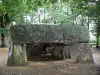
| Monuments |
|---|
| Last name | Outing type | Difficulty | Duration | Departure municipality |
|---|---|---|---|---|
 | Cycling itinerary | Easy | 1:15 | Rougé (22 km) |
 | Hike | Easy | 2:05 | Oudon (33 km) |
 | All-terrain bike itinerary | Easy | 1:20 | Ingrandes-Le Fresne sur Loire (36 km) |
 | Hike | Easy | 1:45 | Prée-d'Anjou (39 km) |
 | Hike | Intermediate | 3:00 | Piré-Chancé (43 km) |