Liven up your holidays!

Saint-Hilaire-les-Courbes

Tourism, holidays & weekends guide in the Corrèze

Saint-Hilaire-les-Courbes - Tourism, holidays & weekends guide in the Corrèze
8.3
6

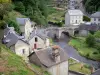
The municipality of Saint-Hilaire-les-Courbes is located in the canton of Treignac and is part of the Regional Natural Park of Millevaches in Limousin.

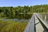
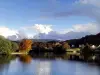
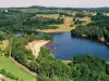
At the heart of a country dotted with streams and ponds, along the Vézère, upstream Lake Viam and downstream Lake Bariousses.

Its distinctive "curves" (las corbas in Occitan) probably alludes to the soft forms of relief that surround the village around the small pond where the waters of its two ponds sleep.

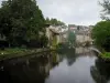
During walks or mountain bike along the GR 440, the circuit between lakes and ponds, or the paths of St Jacques de Compostela, you can discover its heritage and the diversity of its nature.

With a surface area of ​​3,636 ha, at an average altitude of 650 m, agriculture is practiced, mainly the breeding of Limousin cows.

Geographical information

MunicipalitySaint-Hilaire-les-Courbes
Postcode19170
Latitude45.6095230 (N 45° 36’ 34”)
Longitude1.8346860 (E 1° 50’ 5”)
AltitudeFrom 484m to 809m
Surface area36.36 km²
Population168 inhabitants
Density4 inhabitants/km²
PrefectureTulle (51 km, 53 min)
Insee code19209
IntercommunalityCC Vézère-Monédières-Millesources
DepartmentCorrèze
TerritoriesLimousin, Massif Central
RegionNew-Aquitaine

Nearest cities & towns

Lacelle6.2 km (6 min)
Viam7.4 km (9 min)
L'Église-aux-Bois8.8 km (10 min)
Bugeat10.3 km (11 min)
Treignac11.4 km (12 min)
Toy-Viam13.5 km (16 min)
Rempnat13.8 km (21 min)
Affieux14.6 km (16 min)
Veix15.1 km (17 min)
Soudaine-Lavinadière15.2 km (16 min)
Pérols-sur-Vézère15.3 km (15 min)
Chamberet18.2 km (19 min)
Lestards18.4 km (20 min)
Tarnac18.4 km (23 min)

Things to see and do

Events and festivities

Garage sale: in May.

Heritage Days: opening of the church, exhibitions paintings / sculptures of local artists, discovery trail in wetland.

Vide-Greniers et Foire Artisanale

Photos

The town
The town
See photo
The church
The church
See photo
The castle
The castle
See photo
The small pond
The small pond
See photo
Trail of Merlettes
Trail of Merlettes
See photo
Communal house
Communal house
See photo
Young deer
Young deer
See photo
Autumn sunset
Autumn sunset
See photo
Cemetery Cross
Cemetery Cross
See photo
Hostel
Hostel
See photo
Stop of the bus early twentieth
See photo

Weather

Thursday 25 april
Min. 4°C - Max. 8°C
Day
Night
Friday 26 april
Min. 5°C - Max. 10°C
Day
Night
Saturday 27 april
Min. 7°C - Max. 13°C
Day
Night

Visits, leisure and activities nearby

Hiking and mountain biking: topo-guides and hiking maps available at the Tourist Office Vézère-Monédières de Treignac: ign maps, map "walks in Vézère Monédières", 27 circuits of small hiking, chamina guide "country of Monédières "24 circuits of small excursion, chamina guide" regional natural park of Millevaches "45 circuits of small excursion," topo-guides walks & excursions "18 walks, and excursions + 4 paths GRP," the way of Rocamadour towards Compostelle "route of Benevent-l'Abbaye Martel, "in the footsteps of Paris-Orleans-Corrèze" 8 routes on the old railway.

Outings

Last nameOuting typeDifficultyDurationDeparture municipality
Vassivière Lake walk
HikeEasy7:00Beaumont-du-Lac (18 km)
Shoreline trail
Village visitAthletic6:00Peyrat-le-Château (22 km)
Bialet Waterfalls
HikeEasy2:30Saint-Ybard (30 km)
In the footsteps of Martin Nadaud
Village visitEasy3:00Soubrebost (39 km)
Verger Gorges
HikeEasy1:30Bourganeuf (39 km)

Restaurants

Bed & breakfasts

Vacation rentals

Campsites

Hotels

Your holidays
A hotel
A vacation rental
A bed & breakfast
A campsite
A leisure activity
A restaurant
A rental car
A plane ticket
By continuing to browse our site, you are agreeing to the use of cookies to improve your experience and make targeted offers.
Find out more and make settings
Your account