

Favourite
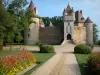
The Anzy-le-Duc church
| Municipality | Saint-Didier-en-Donjon |
|---|---|
| Postcode | 03130 |
| Latitude | 46.3884890 (N 46° 23’ 19”) |
| Longitude | 3.8597820 (E 3° 51’ 35”) |
| Altitude | From 250m to 321m |
| Surface area | 32.92 km² |
| Population | 252 inhabitants |
| Density | 7 inhabitants/km² |
| Prefecture | Moulins (58 km, 58 min) |
| Insee code | 03226 |
| Intercommunality | CC Entr'Allier Besbre et Loire |
| Department | Allier |
| Territories | Auvergne, Bourbonnais, Massif Central |
| Region | Auvergne-Rhône-Alps |
| Neuilly-en-Donjon | 6.5 km (12 min) |
|---|---|
| Le Pin | 6.7 km (9 min) |
| Saint-Léger-sur-Vouzance | 7.7 km (12 min) |
| Monétay-sur-Loire | 8 km (14 min) |
| Luneau | 8.4 km (13 min) |
| Le Donjon | 8.5 km (9 min) |
| Liernolles | 9.1 km (14 min) |
| Le Bouchaud | 11.7 km (18 min) |
| Molinet | 13 km (13 min) |
| Chassenard | 13.5 km (19 min) |
| Vindecy | 13.6 km (21 min) |
| Avrilly | 14.7 km (23 min) |
| Saint-Léon | 15.4 km (21 min) |
| Bourg-le-Comte | 15.5 km (22 min) |
| Last name | Activity type | Rate | City |
|---|---|---|---|
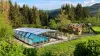
 | Well-being | 65 € to 155 € | Ferrières-sur-Sichon (44 km) |
| Last name | Outing type | Difficulty | Duration | Departure municipality |
|---|---|---|---|---|
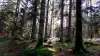
 | Cycling itinerary | Easy | 2:00 | Marcigny (18.8 km) |
 | Hike | Intermediate | 40 min | Bellerive-sur-Allier (45 km) |
 | Hike | Intermediate | 3:00 | La Boulaye (45 km) |
 | Hike | Easy | 1:30 | Saint-Eugène (46 km) |
 | Hike | Easy | 3:00 | Besson (47 km) |