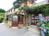


Favourite
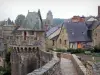
Vitré
| Municipality | Saint-Didier |
|---|---|
| Postcode | 35220 |
| Latitude | 48.0955550 (N 48° 5’ 44”) |
| Longitude | -1.3718060 (W 1° 22’ 19”) |
| Altitude | From 40m to 97m |
| Surface area | 14.14 km² |
| Population | 2070 inhabitants |
| Density | 146 inhabitants/km² |
| Prefecture | Rennes (26 km, 29 min) |
| Insee code | 35264 |
| Intercommunality | CA Vitré Communauté |
| Department | Ille-et-Vilaine |
| Region | Brittany |
| Saint-Jean-sur-Vilaine | 3 km (6 min) |
|---|---|
| Domagné | 3.7 km (7 min) |
| Châteaubourg | 4.4 km (9 min) |
| Cornillé | 5.4 km (7 min) |
| Marpiré | 7.6 km (9 min) |
| Saint-Aubin-des-Landes | 7.6 km (13 min) |
| Broons-sur-Vilaine | 7.9 km (12 min) |
| Louvigné-de-Bais | 9.4 km (12 min) |
| Torcé | 9.8 km (15 min) |
| Servon-sur-Vilaine | 10.2 km (12 min) |
| Champeaux | 10.6 km (14 min) |
| Brécé | 10.7 km (11 min) |
| Pocé-les-Bois | 12 km (14 min) |
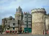
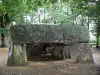
| Monuments |
|---|
| Last name | Outing type | Difficulty | Duration | Departure municipality |
|---|---|---|---|---|
 | Hike | Intermediate | 2:45 | Châteaugiron (10.6 km) |
 | Hike | Intermediate | 3:00 | Piré-Chancé (10.8 km) |
 | All-terrain bike itinerary | Intermediate | 2:05 | Châteaugiron (11 km) |
 | All-terrain bike itinerary | Intermediate | 2:05 | Châteaugiron (11.1 km) |
 | Hike | Intermediate | 2:10 | La Bouëxière (11.1 km) |