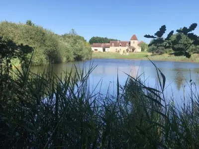
The town of Saint-Aigny is located on the left bank of the Creuse, it has woods and rocky cliffs make fun camping. The latter will not fail to discover the church of Saint-Aignan and to drink at its source.


Favourite
The town of Saint-Aigny is located on the left bank of the Creuse, it has woods and rocky cliffs make fun camping. The latter will not fail to discover the church of Saint-Aignan and to drink at its source.
| Municipality | Saint-Aigny |
|---|---|
| Postcode | 36300 |
| Latitude | 46.6452550 (N 46° 38’ 43”) |
| Longitude | 1.0257000 (E 1° 1’ 33”) |
| Altitude | From 72m to 141m |
| Surface area | 14.86 km² |
| Population | 286 inhabitants |
| Density | 19 inhabitants/km² |
| Prefecture | Châteauroux (61 km, 1:03) |
| Insee code | 36178 |
| Intercommunality | CC Brenne - Val de Creuse |
| Department | Indre |
| Territory | Berry |
| Region | Centre-Loire Valley |
| Sauzelles | 3.3 km (5 min) |
|---|---|
| Le Blanc | 4.1 km (8 min) |
| Fontgombault | 6.4 km (11 min) |
| Concremiers | 8 km (13 min) |
| Pouligny-Saint-Pierre | 10.4 km (14 min) |
| Mauvières | 10.5 km (14 min) |
| Preuilly-la-Ville | 10.5 km (16 min) |
| Mérigny | 10.6 km (15 min) |
| Lurais | 10.7 km (15 min) |
| Ingrandes | 11 km (12 min) |
| Saint-Hilaire-sur-Benaize | 11.3 km (12 min) |
| Ruffec | 12.2 km (15 min) |
| Douadic | 13.7 km (16 min) |
| Tournon-Saint-Martin | 13.7 km (20 min) |
| Natural sites |
|---|
| Last name | Outing type | Difficulty | Duration | Departure municipality |
|---|---|---|---|---|
 | Hike | Easy | 40 min | Nalliers (13.1 km) |
 | Hike | Easy | 2:35 | Saint-Savin (15.2 km) |
 | Car itinerary | Easy | 30 min | Saint-Savin (15.2 km) |
 | Hike | Easy | 50 min | Saint-Savin (15.2 km) |
 | Car itinerary | Easy | 30 min | Saint-Savin (15.2 km) |