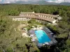
- A city in which to live ...
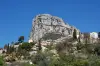
- Roquefort-les-Pins part way around Grasse, formed by the northern plateau of Valbonne and identified by the high cliffs of the Gorges du Loup. Apart from the sector Gorgue, representing a conglomerate based volcanic elements, elsewhere the area of limestone predominates.
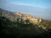
- The town offers a succession of hamlets and peaceful green areas around the forest Roquefortoise, protected area. In recent years, the population rose sharply, thanks to the attractiveness of the city. To cope with these changes, Michael Rossi, Deputy Mayor of the town has adapted existing planning and creating new public buildings: the children's nursery Gum Ball, Layet Boutonnier kindergarten, college and Caesar the gymnasium, the sports complex (stadium, tennis courts, skate park), the leisure center, cinema Blue Flag, the cultural center the Good Home (library and tourist), a new clubhouse for tennis and the development of public transport (ICILA Envibus in addition to regular routes), the renovation of the drinking water system, installation of surveillance cameras, the doubling of the school, the gendarmerie, the Post and local associations.
- Roquefort continues its development with plans to build new housing areas, public facilities and businesses. Finally, the variety of sporting, cultural and associative reflect the commitment of the municipality to meet all expectations Roquefortois, regardless of their age, thus creating a dynamic, harmonious, convenient, quality certain life, a real village in the heart of the triangle Nice-Antibes-Grasse.
- History:
- From ancient remains, including the menhir located on the edge of Roquefort and Rouret and a dolmen located in Notre-Dame, it can be concluded that the municipality has been inhabited since the Bronze Age (Museum of History of Grasse in Provence).
- The tribes there Celtoligures practiced farming and agriculture. In that time we have left the names of "Tourres" and "Camptracier" that designate areas where they found the remains of the camps where people took refuge in case of danger.
- Roquefort is on a spur connecting the Aurelian Way Pont-du-Loup in Grasse by Opio. Indeed, the Romans, noting the mild climate, established a rest camp at Notre Dame de Canlache (Campo laxio) which is placed in the church.
- Following a series of donations, most of the land became the 12th s, the property of the Abbey of Lerins. The monks of Lerins enjoyed at this time of the esteem of the Roman Pontiff and of the Counts of Provence, these donations were confirmed by a bull of Pope Innocent II in 1139 and a letter from Raymond Béranger third in 1167. To meet its debts, the monastery from 1241 sold it to the community of St. Paul, with the exception of the Church of St. Peter. In fact, Roquefort, as St. Paul and Grasse, depends only on the sovereign Count of Provence, which reserves the legal blood and appoint a Bailiff Seigneurial.
- The community of St. Paul was twice confirmed its privileges by the Queen Jeanne May 7, 1366 and Queen Marie May 3, 1390. Now members of the community can take fief, justice and sharing the land of Roque-fort. In 1471, the book terrier (register containing the laws and customs of a domain) is made of Roquefort. All these privileges were respected by Louis XI.
- Until the 16th century, Roquefort is virtually uninhabited. In 1537, François 1st, then at war against Charles V ordered the construction of the ramparts of Saint Paul and compensate the dispossessed by the division of lands of Roquefort. Some 400 heads of families relocating to the Colle-sur-Loup and Roquefort. These families organized into clans, sometimes quite opposite to each other, thus shaping the current appearance of the town, that is to say a collection of hamlets.
- The first register of civil status is established in 1691 and held by the clergy.
- In 1714, the community of St. Paul is selling some portions of the territory of Roquefort. All buyers are, in 1718, the noble title of Co-lords of Roquefort their families have retained. These Alziari, of Mougins (ennobled in 1821 by Louis XVIII) and Bellesime.
- It was not until 1790 that the town gained its independence at that time, the village was still a rough country crossed paths so stony that its inhabitants were called "Lei souto bushes." Roquefortois the farmers were all except two artisans. In 1851 the population was 812 souls. The chief town, Our Lady of Canlache, housed the parish church and parsonage. The place served as a meeting place for residents of other villages, Romanil, Plan, Font Cubert, the Tourres, San Peyre (Saint Peter) or Terres Blanches. Today the town displays nearly 6500 people.
")