Liven up your holidays!

Rieulay

Tourism, holidays & weekends guide in the Nord

Rieulay - Tourism, holidays & weekends guide in the Nord
8.8
6

Rieulay is a mining town suburban areas under the influence of the industrial sector Somain-Pecquencourt but is also a rural town in the valley of the Scarpe its boundary with the mining area.

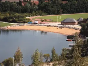
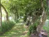
The village opens to Marchiennes a feature of the wet valley agricultural and natural area classified as an area of ​​ecological interest flora and fauna, justifying his membership in the Regional Natural Park Scarpe Escaut.

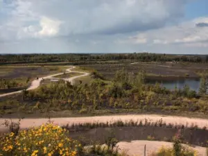
This town also has on its territory the largest flat heap of Nord-Pas-de-Calais with 140 ha.

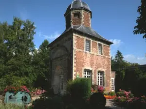
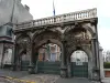
Locality Rieulay existed long before the year 800 through a Gallo-Roman villa. At the end of the 12th century, the Chevalier Pierre Douay became the possessor. He built in 1215 a castle and a chapel in 1217.

In 1712, during the Battle of Denain, the Austrians had established their camp on the outskirts of Rieulay and stored supplies and ammunition along the Scarpe.

During the Revolutionary period, the population of Rieulay was calm, the chapel was spared and became a parish church in the Concordat of 1804.

Finally, during the two world wars, Rieulay suffered invasions and German occupations. It was released October 19, 1918 by English troops and September 2, 1944 by U.S. troops.

Geographical information

MunicipalityRieulay
Postcode59870
Tourism label
Latitude50.3789900 (N 50° 22’ 44”)
Longitude3.2539930 (E 3° 15’ 14”)
AltitudeFrom 16m to 27m
Surface area7.29 km²
Population1283 inhabitants
Density175 inhabitants/km²
PrefectureLille (53 km, 39 min)
Insee code59501
IntercommunalityCC Cœur d'Ostrevent
DepartmentNord
TerritoryFlandre-Artois
RegionHauts-de-France

Nearest cities & towns

Bruille-lez-Marchiennes2.6 km (4 min)
Vred3.1 km (5 min)
Pecquencourt4.4 km (6 min)
Somain4.4 km (6 min)
Écaillon4.8 km (7 min)
Marchiennes5.3 km (6 min)
Masny6.1 km (10 min)
Fenain6.4 km (10 min)
Wandignies-Hamage7.4 km (11 min)
Abscon8.6 km (9 min)
Warlaing8.8 km (13 min)
Aniche9 km (12 min)
Lallaing9.1 km (11 min)
Bouvignies9.3 km (11 min)
Loffre9.4 km (15 min)

Things to see and do

The House of the heap, museum on the history of coal mining and geology.

The pond Argalis and its leisure at the foot of the heap.

The heap: It is made from the early 20th century by the sterile products Somain neighboring pits and Pecquencourt, gradually covering a wetland and woodland bordering the village to the west and forming a continuous screen of 25 m high . Built largely before the invention of washing, it contains a significant proportion of combustible material, which justified its use by the Coal Mines Basin Nord-Pas-de-Calais from 1975. This operation was used to recover coal that was used for the operation of thermal power Hornaing. The treatment was 7 000 tons a day! Use this operation with the railway does not allow development. In 1977, the Mayor got a test to be conducted along the farm where a pond was dug. He showed that rehabilitation could quickly lead to a new landscape. Exemplary collaboration between the municipality and the company Tercharnor helped organize a redevelopment of wasteland as and when its operation. The heap has followed three lines of development: economic and cultural, tourism and leisure environment.

The Castle: The moats were fed by a diversion of Great Traitoire, the gap of 24 feet and by the flowing nearby. The buildings were composed of 3 large round towers topped with domes of brick. The tower was made of 4 large wings covered with slate. The construction extends from 1207 to 121: it is the feudal castle Rieulay, which built his mansion in the Flemish in the mid 16th century.

The pigeon: Built between 1705 and 1708, it is in place and place of the old dungeon. It consists of a square tower of brick and limestone, topped by an octagonal turret with a slate roof. It was bought by the Compagnie des Mines d'Aniche into housing Houllières National Guards until 1969. Released in 1970, he eventually became property of the Scarpe Escaut Nature Park and turned into a cottage. He is listed as a historic monument since December 19, 1973. There was also supposed, the farm of the castle, where you can see today that the portal arch leading to the school.

Events and festivities

Fl'Aureily: flower festival, local produce and sustainable development in May.

Cultural decade in November.

Farmers' Market: 2nd Sunday of each month.

Farmers' Market: Structure development and marketing of local produce, open Tuesday through Saturday from 3:00 p.m. to 7:00 p.m..

Photos

Terril
Terril
See photo
Dovecote
Dovecote
See photo
Beach
Beach
See photo
Lake and nature reserve
See photo

Weather

Saturday 20 april
Min. 4°C - Max. 10°C
Day
Night
Sunday 21 april
Min. 3°C - Max. 12°C
Day
Night
Monday 22 april
Min. 3°C - Max. 10°C
Day
Night

Visits, leisure and activities nearby

Leisure activities

Last nameActivity typeRateCity
Beer Tasting Treasure Hunt in Lille
Entertainment29 € Lille (32 km)
Interactive treasure hunt around the secrets of Lille - In French
Entertainment24 € Lille (32 km)
Skip-the-Line E-Ticket – Villa Cavrois
Culture and education9 € Croix (33 km)

Outings

Last nameOuting typeDifficultyDurationDeparture municipality
Cambrai Baroque
HikeEasy20 minCambrai (23 km)
Brave Trail (Serre-lès-Puisieux)
HikeEasy3:05Beaumont-Hamel (53 km)
Fao Trail (Grand-Rullecourt)
HikeEasy4:55Grand-Rullecourt (57 km)
Trail of the Woods
HikeIntermediate2:40Pas-en-Artois (60 km)
Wolf Trail (Berlencourt-le-Cauroy)
HikeEasy4:10Berlencourt-le-Cauroy (60 km)

Restaurants

Bed & breakfasts

Vacation rentals

Campsites

Hotels

Your holidays
A hotel
A vacation rental
A bed & breakfast
A campsite
A leisure activity
A restaurant
A rental car
A plane ticket
By continuing to browse our site, you are agreeing to the use of cookies to improve your experience and make targeted offers.
Find out more and make settings
Your account