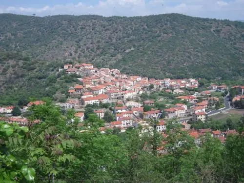
Ria-Sirach is a municipality in the Pyrénées-Orientales, in the Occitanie region, west of Prades, which it borders on.
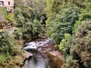
Its 13 km² territory ranges from 339 to 1081 m above sea level, in the Têt valley, in the heart of the natural and historic region of Conflent, a former county dominated by Canigou in the south and the massif of Madrès in the north and which had Prades as its capital.
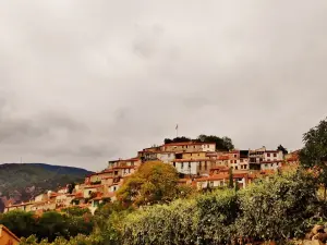
The locality retains a very rural landscape, 20% of the land remaining covered with forests and 65% with meadows…
However, the history of the town is very old. Since the Middle Ages, the parish of Sirach (on the right bank of the Tet) depended on its neighbor of Ria (on the left bank). The municipalities merged in 1822, then in 1973, after the absorption of Urbanya, its name became Ria-Sirach-Urbanya before being simplified in 1983 into "Ria-Sirach".
From 1134 until the Revolution, the two parishes had depended on the Abbey of Saint-Michel de Cuxa, Ria also being the seat of a seigneury with a castle.
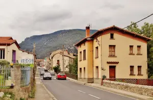
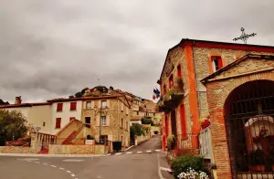
In the 19th century, wood-fired blast furnaces were installed to produce iron of renowned quality, an activity which was stopped after the Second World War. With around 1400 inhabitants, the locality remains urbanized only on either side of the Têt and the RN 116 which leads to Andorra. It has a heritage, an environment and a leisure offer of interest.
The former seigneury of Ria and the various parishes that today make up the territory of the municipality have left a rich and varied heritage in terms of heritage.
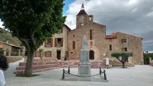
Originally built on a hill in the 12th century, the castle of Ria was destroyed in the 17th century, having already been rebuilt in the 16th century after wars led by the King of Aragon. Of the double bastioned enclosure, only the base of the walls remains… On Ria again, the Saint-Vincent church founded in the 11th century and built in a Romanesque style has only retained its quadrangular bell tower 22 m high, at the level of the north facade. The rest of the building, listed in the Inventory (because of its tower but also of the gate leaves), was altered in the 17th and 18th centuries.
The church of Saint-Clément in Sirach dates from the 12th century. Its Romanesque form was basic, with a single barrel-vaulted nave and an apse ending in a cul-de-four. During the following centuries, due to the disturbances which affected the region, the whole was raised and fortified. Hence a massive and austere appearance. Finally, in the 18th century, chapels were added to the sides of the nave. The church is also protected as a historical monument.
Finally, we must also mention the Saint-Christophe church in the hamlet of Llugols, in Romanesque style, well preserved, while the nearby Saint-Sernin church is in ruins…
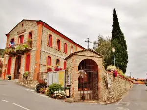
On the cultural side, the Georges Chambon media library, housed in the old rectory of Ria, has a digital space. It also regularly hosts exhibitions of artists from the region or program of events (conferences, meetings, readings). For more information, call +33 4 68 05 89 47.
As far as "nature" leisure activities are concerned, the green environment and the Pyrenean terrain allow Ria-Sirach to have very substantial potential.
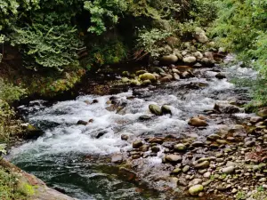
Let us note first of all that fishermen can take advantage of the Têt and its tributaries descending from neighboring peaks. Information on the developed sites and the regulations on +33 6 13 26 56 97.
Then mention the club of Castellane which offers courses and excursions on the Canigou massif and its neighbors aboard 4x4 vehicles. An original way to discover the landscape while respecting the recommendations of the National Forestry Office. Contact on +33 4 68 05 27 08.
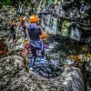
Experienced guides also supervise snowshoe hikes (in winter) or hiking and water hikes (by walking up mountain streams) in summer: inquire at +33 6 63 51 96 88.
On the territory of the town itself, the 8.5 km long, signposted Pin du Roi hiking trail allows you to understand the different facets of the town, in terms of heritage and natural. The route includes some difficulties but remains accessible to the general public.
On the other hand, the Chemin des Origines (in Catalan, "El cami des origens") which can be reached from the town, is 92 km long and known to be demanding. It connects villages and emblematic sites of the old counties which later gave birth to Catalonia.
Other routes and loops allow you to discover the surroundings of the Ambouilla cave (from which experienced speleologists access a network of 35 km of galleries) or to follow the valley upstream (towards Andorra) or downstream.
Maps and information on +33 4 68 05 41 02.
The last weekend of January, patronal feast of Saint Vincent with convivial meal and musical entertainment.
At the beginning of March, carnival round in Sirach.
The second Sunday in May, garage sale.
At the end of June, in Ria, Saint John festivities with torchlight retreat and musical show.
The first weekend of August, Sardana festival.