Liven up your holidays!

Pourcieux

Tourism, holidays & weekends guide in the Var

Geographical information

MunicipalityPourcieux
Postcode83470
Latitude43.4712960 (N 43° 28’ 17”)
Longitude5.7856280 (E 5° 47’ 8”)
AltitudeFrom 278m to 870m
Surface area21.23 km²
Population1590 inhabitants
Density74 inhabitants/km²
PrefectureToulon (63 km, 1:02)
Insee code83096
IntercommunalityCA de la Provence Verte
DepartmentVar
TerritoriesFrench Riviera, Provence
RegionProvence-Alps-French Riviera

Nearest cities & towns

Ollières5.6 km (8 min)
Pourrières7.2 km (9 min)
Saint-Maximin-la-Sainte-Baume7.4 km (9 min)
Trets9.4 km (11 min)
Seillons-Source-d'Argens12.4 km (15 min)
Puyloubier13.7 km (14 min)
Peynier14 km (15 min)
Rousset14.7 km (16 min)
Tourves14.7 km (17 min)
Rougiers14.8 km (19 min)
Bras16.4 km (19 min)
Brue-Auriac18 km (17 min)
Châteauneuf-le-Rouge18.5 km (17 min)
Nans-les-Pins19.4 km (23 min)

Things to see and do

The bike track Pourcieux said the Sainte-Baume, was established on 21 October 2006, for a distance of about 15 km (round trip) to Saint-Maximin, the Gardanne Carnoules-line. This line is closed to regular traffic since 1983, it is classified strategic demand of the military authorities. The goal is to preserve an alternative route from Marseille to Toulon where the main line becomes impractical. It is a scenic way to explore the stunning scenery of the village, passing over viaducts Sainte Baume is particularly striking, as well as the view of the plain of Saint-Maximin, and the Basilica from an unusual angle. Crossing the Saint Pilon tunnel (180 m) complete the enchantment. The track bike is, unless medically indicated against an activity accessible to all. By adopting a pedaling flexibility, its use is not difficult, you only need to follow simple safety instructions given to you before departure. The rail bike runs all year round availability of the railway line sometimes used next. Reservation is required at +33 6 33 81 50 87 or +33 4 94 72 79 93.

Places of interest

Natural sites

Events and festivities

Village Festival the first half of July.

Photos

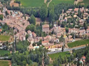
The village
The village
See photo

Weather

Tuesday 23 april
Min. 1°C - Max. 14°C
Day
Night
Wednesday 24 april
Min. 3°C - Max. 15°C
Day
Night
Thursday 25 april
Min. 4°C - Max. 15°C
Day
Night

Visits, leisure and activities nearby

Leisure activities

Last nameActivity typeRateCity
Outdoor show: Letters from my Windmill
Entertainment17 € Le Tholonet (23 km)
Segway Tour of Aix-en-Provence – 2 hours
Entertainment50 € Aix-en-Provence (28 km)
Trip to the Villages of Luberon with Regional Wine Tasting
Entertainment155 € Aix-en-Provence (28 km)
Aix-en-Provence & Pays d'Aix City Pass : Tours, Activities, Museums & Transportation
Entertainment29 € Aix-en-Provence (28 km)
Explore the Hilltop Villages of Luberon
Entertainment85 € Aix-en-Provence (28 km)

Outings

Last nameOuting typeDifficultyDurationDeparture municipality
Sainte-Victoire Mountain - Saint-Ser Chapel
HikeIntermediate1:30Puyloubier (10.9 km)
Caramy Gorges
HikeEasy4:00Tourves (13.2 km)
Saint-Probace Chapel
HikeEasy2:00Tourves (13.2 km)
Between Sainte-Victoire and Sainte-Baume
HikeEasy4:00La Destrousse (18 km)
Hiking and biking trails in Gréasque
Mountain bike itineraryEasy1:00Gréasque (19.6 km)

Restaurants

Bed & breakfasts

Vacation rentals

Campsites

Hotels

Your holidays
A hotel
A vacation rental
A bed & breakfast
A campsite
A leisure activity
A restaurant
A rental car
A plane ticket
By continuing to browse our site, you are agreeing to the use of cookies to improve your experience and make targeted offers.
Find out more and make settings
Your account