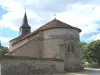
To see the church with inscriptions in Arabic inside.
The stud and horses.

| Municipality | Parsac-Rimondeix |
|---|---|
| Postcode | 23140 |
| Latitude | 46.2014840 (N 46° 12’ 5”) |
| Longitude | 2.1530280 (E 2° 9’ 11”) |
| Altitude | From 353m to 503m |
| Surface area | 47.02 km² |
| Population | 726 inhabitants |
| Density | 15 inhabitants/km² |
| Prefecture | Guéret (25 km, 21 min) |
| Insee code | 23149 |
| Intercommunality | CC Creuse Confluence |
| Department | Creuse |
| Territories | Limousin, Massif Central |
| Region | New-Aquitaine |
| Domeyrot | 6.2 km (9 min) |
|---|---|
| Gouzougnat | 6.5 km (11 min) |
| Jarnages | 6.8 km (10 min) |
| Blaudeix | 7.2 km (10 min) |
| Saint-Dizier-la-Tour | 7.3 km (14 min) |
| Saint-Silvain-sous-Toulx | 8.5 km (13 min) |
| Gouzon | 8.6 km (9 min) |
| La Celle-sous-Gouzon | 9.1 km (10 min) |
| Vigeville | 10.9 km (16 min) |
| Chénérailles | 11.1 km (18 min) |
| Cressat | 11.2 km (15 min) |
| Trois-Fonds | 12.7 km (12 min) |
| Ladapeyre | 12.8 km (15 min) |
| Ajain | 13.2 km (13 min) |
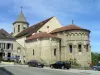
To see the church with inscriptions in Arabic inside.
The stud and horses.
| Transport |
|---|
Every last weekend of August held a garage sale quality.
| Last name | Outing type | Difficulty | Duration | Departure municipality |
|---|---|---|---|---|
 | Car itinerary | Easy | 1:00 | Ahun (15.1 km) |
 | Hike | Easy | 2:00 | Chambon-sur-Voueize (21 km) |
 | Car itinerary | Easy | 1:35 | Évaux-les-Bains (26 km) |
 | Hike | Intermediate | 2:20 | Évaux-les-Bains (26 km) |
 | Hike | Easy | 2:00 | Évaux-les-Bains (26 km) |