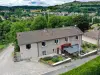
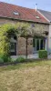
A 6 km east of The Underground, Noth is a rural community characterized by the presence of the beautiful lake of Cazin.


Favourite


A 6 km east of The Underground, Noth is a rural community characterized by the presence of the beautiful lake of Cazin.
| Municipality | Noth |
|---|---|
| Postcode | 23300 |
| Latitude | 46.2351260 (N 46° 14’ 6”) |
| Longitude | 1.5869960 (E 1° 35’ 13”) |
| Altitude | From 339m to 453m |
| Surface area | 22.89 km² |
| Population | 502 inhabitants |
| Density | 21 inhabitants/km² |
| Prefecture | Guéret (28 km, 24 min) |
| Insee code | 23143 |
| Intercommunality | CC du Pays Sostranien |
| Department | Creuse |
| Territories | Limousin, Massif Central |
| Region | New-Aquitaine |
| Lizières | 3.8 km (8 min) |
|---|---|
| Naillat | 6.6 km (10 min) |
| Saint-Léger-Bridereix | 7.1 km (10 min) |
| Saint-Priest-la-Feuille | 7.6 km (14 min) |
| Saint-Priest-la-Plaine | 8.8 km (11 min) |
| Colondannes | 9.7 km (14 min) |
| Chamborand | 11.1 km (19 min) |
| La Souterraine | 11.5 km (16 min) |
| Le Grand-Bourg | 11.5 km (16 min) |
| Sagnat | 12.4 km (16 min) |
| Fleurat | 12.4 km (11 min) |
| Saint-Agnant-de-Versillat | 13.4 km (18 min) |
| Dun-le-Palestel | 13.9 km (16 min) |
| Saint-Germain-Beaupré | 13.9 km (16 min) |
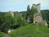
The fortifications of the church (XIth and 14th century).
The arboretum of the FOT: 2 ha mingling hardwoods and conifers of all kinds.
The pond Cazine (54 ha): carp fishing.
Walking starting from the village and around the pond Cazine.
Bike rides from the base of the FOT.
| Last name | Outing type | Difficulty | Duration | Departure municipality |
|---|---|---|---|---|
 | Car itinerary | Easy | 45 min | Saint-Sébastien (17.9 km) |
 | Hike | Easy | 4:00 | Saint-Léger-la-Montagne (26 km) |
 | Hike | Easy | 6:00 | Razès (30 km) |
 | Hike | Easy | 3:00 | Moutier-Malcard (33 km) |
 | Hike | Easy | 1:30 | Bourganeuf (34 km) |