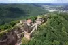
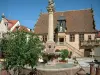
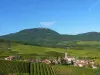
Located at the entrance to the valley of the Bruche Mutzig City is strategically located on the slopes of the Vosges foothills.


Favourite


Located at the entrance to the valley of the Bruche Mutzig City is strategically located on the slopes of the Vosges foothills.
| Municipality | Mutzig |
|---|---|
| Postcode | 67190 |
| Tourism label | ") |
| Latitude | 48.5367840 (N 48° 32’ 12”) |
| Longitude | 7.4586210 (E 7° 27’ 31”) |
| Altitude | From 180m to 397m |
| Surface area | 8.01 km² |
| Population | 6136 inhabitants |
| Density | 766 inhabitants/km² |
| Prefecture | Strasbourg (30 km, 24 min) |
| Insee code | 67313 |
| Intercommunality | CC de la Région de Molsheim-Mutzig |
| Department | Bas-Rhin |
| Territory | Alsace |
| Region | Great East |
| Gresswiller | 2.8 km (5 min) |
|---|---|
| Molsheim | 3.3 km (5 min) |
| Dorlisheim | 3.7 km (8 min) |
| Dinsheim-sur-Bruche | 4.7 km (14 min) |
| Still | 4.8 km (8 min) |
| Heiligenberg | 5.6 km (10 min) |
| Avolsheim | 5.7 km (9 min) |
| Dangolsheim | 6.2 km (11 min) |
| Bergbieten | 7.1 km (13 min) |
| Rosenwiller | 7.2 km (14 min) |
| Soultz-les-Bains | 7.3 km (11 min) |
| Wolxheim | 7.6 km (14 min) |
| Dachstein | 7.7 km (13 min) |
| Flexbourg | 7.9 km (14 min) |
| Bischoffsheim | 8.2 km (11 min) |
| Leisure centres | |
|---|---|
| Monuments | |
| Performance halls | |
| Transport |


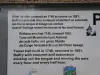


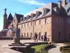
A tour is available at City Hall or the Tourist Office of Molsheim - Mutzig (located in nearby Molsheim ). With a duration of 1:30, the tour takes visitors to explore the old town. Markup in place, so that visitors can do without retrieving the document first. Out in the parking lot next to City Hall.
| Last name | Activity type | Rate | City |
|---|---|---|---|
 | Entertainment | 24 € | Strasbourg (22 km) |
 | Arts and Crafts | Free | Ranrupt (28 km) |
 | Arts and Crafts | 50 € | Hoerdt (30 km) |
 | Local flavours | Free | Rodern (36 km) |
 | Sports sensations | 25 € to 80 € | Niederbronn-les-Bains (48 km) |
| Last name | Outing type | Difficulty | Duration | Departure municipality |
|---|---|---|---|---|
 | Village visit | Easy | 1:30 | Mutzig |
 | Village visit | Easy | 1:00 | Molsheim (2.5 km) |
 | Village visit | Easy | 1:30 | Altorf (5.9 km) |
 | Hike | Intermediate | 5:00 | Boersch (6.7 km) |
 | Cycling itinerary | Easy | 3:00 | Osthoffen (9.1 km) |