Montmelard is a commune of Saône-et-Loire, in the Burgundy-Franche-Comté region, 30 km south-east of Paray-le-Monial, on the borders of the Rhone department.
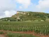
The approximately 22 km² of the territory of the locality are at the crossroads of the natural regions of Haut Clunisois and Charolais, and present a landscape of grove that dominates Mount Saint-Cyr, culminating point of the Mâconnais mountains at 771 m altitude.
Composed of a small village, dotted with hamlets, wetlands (ponds), pastures (cattle and goat farms) and many wooded parcels, Montmelard has only about 350 inhabitants but in the nineteenth century, the population was three more important.
Former parish of Cluny Abbey, the parish was founded at the end of the first millennium.
Montmelard is a popular stop for green tourism enthusiasts.
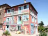
If the village itself is not devoid of charm, with its imposing church dedicated to St. Bartholomew, remodeled in the nineteenth century, its monument to the allegorical deaths and dwellings partly traditional, it is the Mont Saint-Cyr that constitutes the major asset of the municipal heritage.
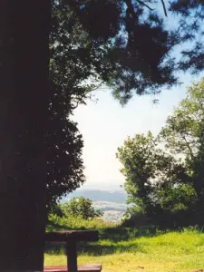
From its wooded summit, the walker or hiker enjoys a 360-degree panoramic view that allows you to contemplate the Charolais to the north and west, the Clunisois and the other mountains of the Mâconnais to the east, the foothills of Beaujolais to south, the mountains of Forez to the southwest. A real geography lesson that facilitates the implementation of orientation tables. In very clear weather, it is sometimes possible to admire in the distance, to the south, the peaks of the Alps.
During a hike to the wooded summit, which was a hotbed of resistance during the Second World War, Nazi troops attacked the maquis of Beaubery in November 1943 at Montmelard, in the heart of these landscapes sometimes dubbed "the little Switzerland of Mâconnais ", we observe a preserved fauna and flora and the remains of a medieval monastery destroyed during the Wars of Religion. A picnic area is set up.
Several marked trails include Mount Saint-Cyr and hillsides, including ponds in the town. Incursions into neighboring localities are also possible (arboretum de Pézanin). Maps and information on +33 3 85 59 72 24.
"Gourmet" breaks are possible on the farm of La Boisette (production of cheeses with cow's milk or goat's milk, contact at +33 3 85 50 90 37) or on the Dufour farm (same types of cheese, contact at +33 3 85 50 23 06) or to discover the stages of the manufacture of artisan soap made from goat's milk (Eaux de l'Elie soap factory, information on +33 3 85 50 29 41 or +33 6 38 34 56 33).
1st Sunday of March, March of Snowdrifts.
In June, night walk.
The second weekend of December, Christmas lights.
Les Voisines Tiennent Portes Ouvertes
- On 4 may 2024
- 3904 route de dompierre
- Les Voisines open house. - Les Voisines is a sales outlet that came into being thanks to the merger of two businesses : côté pain (organic sourdough bread) and le pied à terre (small-scale organic market gardening), both of which welcome other local producers. On the day of the event, there will be a sale of vegetable seedlings as well as a farm visit for those interested. The event will be attended by a number of local producers and craftspeople. You'll be able to eat on site, stroll around, chat… music and good humour on the programme !
Marche
- On 5 may 2024
- Mairie
- 8 km circuit : 1 feed station. 14 km circuit : 2 feed stations. 20 km circuit : 3 feed stations. Climb to the summit of Saint-Cyr (771 metres). Discover the Brionnais countryside.
Balade Nocturne
- On 9 july 2024
- Bourg, Place du Village
- Calling all walkers ! - Every week, set off to discover the region thanks to the thirteenth edition of night-time walks organised by the communes in partnership with the Verts Vallons de Sud Bourgogne Tourist Office. - The route is 6 to 8 km long and takes around 2 hours to complete. A leisurely stroll. Snacks provided by the local authorities at the end of the walk. Walkers are responsible for their own safety.