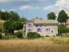
Castle Montmaur
The mielerie.
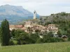
The hamlet of La Montagne.
The forest of the saved (the starting point of GR southern Massif Pic de Bure).
| Municipality | Montmaur |
|---|---|
| Postcode | 05400 |
| Latitude | 44.5707140 (N 44° 34’ 15”) |
| Longitude | 5.8736910 (E 5° 52’ 25”) |
| Altitude | From 849m to 2680m |
| Surface area | 48.77 km² |
| Population | 552 inhabitants |
| Density | 11 inhabitants/km² |
| Prefecture | Gap (21 km, 22 min) |
| Insee code | 05087 |
| Intercommunality | CC Buëch-Dévoluy |
| Department | Hautes-Alpes |
| Territories | Alps, Dauphiné |
| Region | Provence-Alps-French Riviera |
| La Roche-des-Arnauds | 7.3 km (8 min) |
|---|---|
| Veynes | 8.6 km (10 min) |
| Furmeyer | 9 km (16 min) |
| Manteyer | 10.5 km (13 min) |
| Châteauneuf-d'Oze | 12.1 km (18 min) |
| Oze | 12.7 km (20 min) |
| La Freissinouse | 14.3 km (17 min) |
| Saint-Auban-d'Oze | 16.2 km (22 min) |
| Pelleautier | 16.2 km (17 min) |
| Rabou | 16.6 km (22 min) |
| Aspres-sur-Buëch | 16.6 km (18 min) |
| Le Saix | 16.8 km (23 min) |
| Neffes | 17.8 km (20 min) |
| Chabestan | 17.8 km (19 min) |
Castle Montmaur
The mielerie.
The hamlet of La Montagne.
The forest of the saved (the starting point of GR southern Massif Pic de Bure).

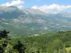
Valley Dévoluy, its ski resorts.
The massif of the Pic de Bure.
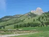
Col du Noyer.
The neck of Festre.
The massive Ceüze.
| Last name | Activity type | Rate | City |
|---|---|---|---|
 | Nature and the great outdoors | 200 € to 1100 € | Ancelle (27 km) |
 | Sports sensations | 44 € | Ubaye-Serre-Ponçon (41 km) |
 | Nature and the great outdoors | 50 € to 375 € | Éourres (42 km) |
 | Sports sensations | 85 € to 115 € | Ubaye-Serre-Ponçon (43 km) |
 | Local flavours | Free | Noyers-sur-Jabron (45 km) |
| Last name | Outing type | Difficulty | Duration | Departure municipality |
|---|---|---|---|---|
 | Hike | Intermediate | 2:15 | La Faurie (10.7 km) |
 | Hike | Easy | 3:00 | Saint-Laurent-du-Cros (20 km) |
 | Hike | Intermediate | 5:00 | La Bâtie-Vieille (23 km) |
 | Hike | Easy | 3:00 | La Bâtie-Vieille (23 km) |
 | Hike | Athletic | 3:00 | Ancelle (27 km) |