


Favourite
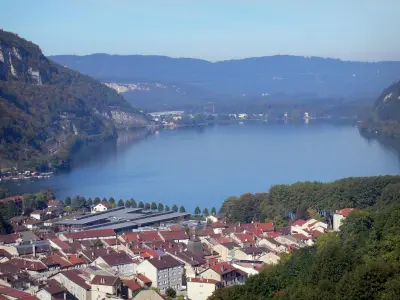
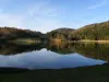
Lake Genin


| Municipality | Montanges |
|---|---|
| Postcode | 01200 |
| Latitude | 46.1649430 (N 46° 9’ 54”) |
| Longitude | 5.8008760 (E 5° 48’ 3”) |
| Altitude | From 375m to 1090m |
| Surface area | 13.70 km² |
| Population | 361 inhabitants |
| Density | 26 inhabitants/km² |
| Prefecture | Bourg-en-Bresse (66 km, 53 min) |
| Insee code | 01257 |
| Intercommunality | CC du Pays Bellegardien |
| Department | Ain |
| Territories | Alps, Jura mountains |
| Region | Auvergne-Rhône-Alps |
| Champfromier | 3.8 km (5 min) |
|---|---|
| Confort | 4.7 km (8 min) |
| Saint-Germain-de-Joux | 7 km (9 min) |
| Chézery-Forens | 9.2 km (13 min) |
| Plagne | 11 km (18 min) |
| Giron | 12.2 km (17 min) |
| Le Poizat-Lalleyriat | 13.2 km (16 min) |
| Échallon | 13.3 km (17 min) |
| Valserhône | 13.6 km (16 min) |
| Charix | 14.6 km (18 min) |
| Villes | 14.8 km (19 min) |
| Billiat | 15.8 km (18 min) |
| Belleydoux | 17.1 km (24 min) |
| Les Neyrolles | 17.4 km (18 min) |


| Last name | Activity type | Rate | City |
|---|---|---|---|
 | Sports sensations | 40 € to 65 € | Saint-Claude (24 km) |
 | Sports sensations | 45 € | Saint-Claude (25 km) |
 | Sports sensations | 280 € | La Balme-de-Sillingy (28 km) |
 | Nature and the great outdoors | 850 € | Monnetier-Mornex (31 km) |
 | Entertainment | 24 € | Annecy (33 km) |
| Last name | Outing type | Difficulty | Duration | Departure municipality |
|---|---|---|---|---|
 | Hike | Athletic | 6:25 | Le Poizat-Lalleyriat (7.6 km) |
 | Hike | Easy | 3:25 | Charix (9.2 km) |
 | Hike | Intermediate | 4:45 | Péron (10 km) |
 | Hike | Athletic | 6:35 | Nantua (15 km) |
 | All-terrain bike itinerary | Easy | 1:30 | Nantua (15.2 km) |


