


Favourite
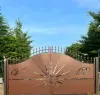
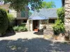
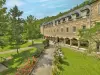
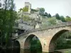
Belcastel
| Municipality | Mayran |
|---|---|
| Postcode | 12390 |
| Latitude | 44.3880350 (N 44° 23’ 17”) |
| Longitude | 2.3633620 (E 2° 21’ 48”) |
| Altitude | From 400m to 734m |
| Surface area | 15.36 km² |
| Population | 645 inhabitants |
| Density | 41 inhabitants/km² |
| Prefecture | Rodez (19.6 km, 22 min) |
| Insee code | 12142 |
| Intercommunality | CC du Pays Rignacois |
| Department | Aveyron |
| Territories | Massif Central, Midi-Pyrénées |
| Region | Occitanie |
| Belcastel | 5.2 km (7 min) |
|---|---|
| Goutrens | 8.6 km (13 min) |
| Rignac | 9.1 km (10 min) |
| Clairvaux-d'Aveyron | 13.5 km (17 min) |
| Escandolières | 13.9 km (24 min) |
| Saint-Christophe-Vallon | 14.9 km (22 min) |
| Moyrazès | 15.1 km (20 min) |
| Druelle Balsac | 15.4 km (15 min) |
| Colombiès | 15.5 km (22 min) |
| Roussennac | 15.9 km (14 min) |
| Anglars-Saint-Félix | 16 km (15 min) |
| Valady | 17.2 km (21 min) |
| Auzits | 18.5 km (28 min) |
| Bournazel | 19.6 km (20 min) |
| Last name | Activity type | Rate | City |
|---|---|---|---|
 | Nature and the great outdoors | 20 € | Clairvaux-d'Aveyron (5.9 km) |
 | Local flavours | 7 € to 12 € | Limogne-en-Quercy (48 km) |
 | Arts and Crafts | 55 € to 140 € | Saint-Martin-de-Lenne (48 km) |
| Last name | Outing type | Difficulty | Duration | Departure municipality |
|---|---|---|---|---|
 | Hike | Easy | 2:30 | Tayrac (23 km) |
 | Hike | Intermediate | 2:10 | Espeyrac (27 km) |
 | Hike | Intermediate | 1:45 | Espeyrac (27 km) |
 | Hike | Intermediate | 2:55 | Espeyrac (28 km) |
 | Hike | Intermediate | 4:00 | Golinhac (30 km) |