Visite 123 Nature : Rucher École
- On 26 may 2024
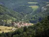
- Hameau de Lucelans, Rucher école de Mathay
- Presentation of the site, beekeeping and the life of bees. Inspection of a hive (weather permitting) and identification of honey cells, pollen, larvae and brood. - Speakers : UAPM - Appropriate attire required : covering clothing and visored cap. - rendez-vous : from 3 p.m. to 5 p.m. at the Mathay apiary school (route du hameau de Lucelans opposite the "l'éperon" equestrian centre) between Voujeaucourt and Mathay (D438).