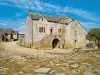
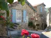
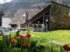
Facing the village you will see a dolmen.
A 1 km from the village stands a chapel called St. Côme.


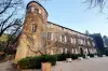
| Municipality | Mas-Saint-Chély |
|---|---|
| Postcode | 48210 |
| Latitude | 44.3095630 (N 44° 18’ 34”) |
| Longitude | 3.3954570 (E 3° 23’ 44”) |
| Altitude | From 800m to 1156m |
| Surface area | 56.81 km² |
| Population | 111 inhabitants |
| Density | 1 inhabitants/km² |
| Prefecture | Mende (37 km, 41 min) |
| Insee code | 48141 |
| Intercommunality | CC Gorges Causses Cévennes |
| Department | Lozère |
| Territories | Languedoc-Roussillon, Massif Central |
| Region | Occitanie |
| Gorges du Tarn Causses | 9.9 km (17 min) |
|---|---|
| Hures-la-Parade | 12 km (17 min) |
| La Malène | 13 km (23 min) |
| Laval-du-Tarn | 18.9 km (29 min) |
| Saint-Pierre-des-Tripiers | 22 km (36 min) |
| Meyrueis | 24 km (31 min) |
| Florac Trois Rivières | 24 km (36 min) |
| Ispagnac | 27 km (38 min) |
| Gatuzières | 29 km (38 min) |
| Bédouès-Cocurès | 29 km (44 min) |
| Le Rozier | 30 km (41 min) |
| Veyreau | 30 km (48 min) |
| Balsièges | 30 km (39 min) |
| Chanac | 30 km (45 min) |
Facing the village you will see a dolmen.
A 1 km from the village stands a chapel called St. Côme.
| Last name | Activity type | Rate | City |
|---|---|---|---|
 | Sports sensations | 35 € | La Canourgue (19.7 km) |
 | Sports sensations | 40 € | Millau (34 km) |
 | Arts and Crafts | 55 € to 140 € | Saint-Martin-de-Lenne (37 km) |
 | Sports sensations | 24 € to 26 € | Comprégnac (43 km) |
 | Local flavours | Free | Roquefort-sur-Soulzon (49 km) |
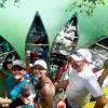
| Last name | Outing type | Difficulty | Duration | Departure municipality |
|---|---|---|---|---|
 | Hike | Intermediate | 4:00 | Hures-la-Parade (8.1 km) |
 | All-terrain bike itinerary | Easy | 2:40 | Sévérac d'Aveyron (26 km) |
 | Hike | Easy | 2:00 | Pont de Montvert - Sud Mont Lozère (28 km) |
 | Hike | Intermediate | 4:00 | Pont de Montvert - Sud Mont Lozère (28 km) |
 | Hike | Athletic | 5:25 | Moissac-Vallée-Française (35 km) |