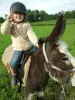
The municipality of Marcilloles houses in its territory animal training center, unique in Isère, making trades in contact with animals, such as ambulance or taxi animal wildlife.


Favourite
The municipality of Marcilloles houses in its territory animal training center, unique in Isère, making trades in contact with animals, such as ambulance or taxi animal wildlife.
| Municipality | Marcilloles |
|---|---|
| Postcode | 38260 |
| Latitude | 45.3400880 (N 45° 20’ 24”) |
| Longitude | 5.1871140 (E 5° 11’ 14”) |
| Altitude | From 288m to 351m |
| Surface area | 9.50 km² |
| Population | 1196 inhabitants |
| Density | 125 inhabitants/km² |
| Prefecture | Grenoble (57 km, 45 min) |
| Insee code | 38218 |
| Intercommunality | CC Bièvre Isère |
| Department | Isère |
| Territories | Alps, Dauphiné |
| Region | Auvergne-Rhône-Alps |
| Viriville | 3.2 km (5 min) |
|---|---|
| Thodure | 3.2 km (6 min) |
| Sardieu | 4.8 km (8 min) |
| Pajay | 5.2 km (10 min) |
| Penol | 6.7 km (9 min) |
| Marnans | 6.9 km (10 min) |
| Beaufort | 7.1 km (10 min) |
| Châtenay | 7.2 km (11 min) |
| Faramans | 7.6 km (12 min) |
| Saint-Siméon-de-Bressieux | 8.8 km (10 min) |
| Lentiol | 9.4 km (13 min) |
| Saint-Barthélemy | 9.6 km (9 min) |
| Ornacieux-Balbins | 9.7 km (15 min) |
| Brézins | 9.9 km (10 min) |
GTAAF animal training center.
| Last name | Activity type | Rate | City |
|---|---|---|---|
 | Nature and the great outdoors | 30 € to 305 € | Flachères (17.7 km) |
 | Entertainment | 130 € to 240 € | Saint-Jean-de-Bournay (18.5 km) |
 | Sports sensations | 15 € to 50 € | L'Isle-d'Abeau (29 km) |
 | Arts and Crafts | 125 € to 300 € | La Tour-du-Pin (32 km) |
 | Sports sensations | 45 € to 75 € | Autrans-Méaudre en Vercors (33 km) |
| Last name | Outing type | Difficulty | Duration | Departure municipality |
|---|---|---|---|---|
 | Cycling itinerary | Intermediate | 2:15 | Beaurepaire (10.5 km) |
 | Hike | Easy | 2:10 | Bévenais (16.8 km) |
 | Cycling itinerary | Easy | 1:35 | Châbons (20 km) |
 | Hike | Intermediate | 3:00 | Saint-Donat-sur-l'Herbasse (29 km) |
 | Hike | Intermediate | 9:00 | Saint-Nazaire-en-Royans (31 km) |