
Favourite
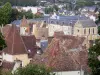
Verneuil-sur-Avre
| Municipality | Manou |
|---|---|
| Postcode | 28240 |
| Latitude | 48.5196479 (N 48° 31’ 11”) |
| Longitude | 0.9801110 (E 0° 58’ 48”) |
| Altitude | From 194m to 277m |
| Surface area | 13.38 km² |
| Population | 622 inhabitants |
| Density | 46 inhabitants/km² |
| Prefecture | Chartres (42 km, 48 min) |
| Insee code | 28232 |
| Intercommunality | CC Terres de Perche |
| Department | Eure-et-Loir |
| Territory | Perche |
| Region | Centre-Loire Valley |
| Fontaine-Simon | 3.6 km (5 min) |
|---|---|
| Meaucé | 4.7 km (6 min) |
| Le Pas-Saint-l'Homer | 5 km (8 min) |
| Les Menus | 5.1 km (6 min) |
| Belhomert-Guéhouville | 5.5 km (8 min) |
| La Loupe | 6.8 km (9 min) |
| Senonches | 7.2 km (12 min) |
| Vaupillon | 8.9 km (13 min) |
| Saint-Éliph | 9.5 km (12 min) |
| Saint-Maurice-Saint-Germain | 9.8 km (13 min) |
| La Madeleine-Bouvet | 11.4 km (12 min) |
| Les Ressuintes | 13.8 km (15 min) |
| Le Mesnil-Thomas | 13.8 km (18 min) |
| Jaudrais | 14.3 km (20 min) |
| Last name | Activity type | Rate | City |
|---|---|---|---|
 | Sports sensations | 22 € to 75 € | Fontaine-Simon (3.1 km) |
| Last name | Outing type | Difficulty | Duration | Departure municipality |
|---|---|---|---|---|
 | Hike | Intermediate | 2:45 | Nonvilliers-Grandhoux (24 km) |
 | Hike | Easy | 3:25 | Saint-Longis (50 km) |
 | Hike | Easy | 2:50 | Mouettes (50 km) |
 | Hike | Easy | 3:15 | Anet (50 km) |
 | All-terrain bike itinerary | Easy | 1:45 | Anet (50 km) |