Liven up your holidays!

Le Monestier

Tourism, holidays & weekends guide in the Puy-de-Dôme

Origin of name: The name of Monestier (Monascola 18th century) describes a small monastery, a name due to the presence of a priory of La Chaise-Dieu.

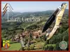
The village center is located in a beautiful location overlooking the east basin Ambert. The granite soil or clay in the depressions is thin.

Le Monestier may have been an important place of settlement in the Gallo-Roman. In fact, Viren, south-east of the town, it has sometimes been seen as remnants of construction the existence of an ancient villa. Elsewhere were found fragments of various origins, a fragment of glass necklace with amber, a bracelet, a handle of a dagger, a small bronze horse.

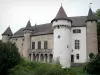
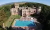
Fiefs and castles: Most of the current municipality was part of the manor of Roche-Savine, mentioned in the Cartulary of Sauxillanges from the 10th century. On a spur of a stronger mound and surrounded by moats, rose early one castle to the 13th century became an important fortress. First possession of Polignac, the lordship passed several hands over the centuries. Around 1724 the manor was purchased by Abraham Peyrenc de Moras, a rich financier residing in Paris, his descendants held it until 1789.

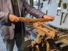
18th century to today: In a poor agricultural country, craft textiles has long been an important resource with the manufacture of laces, and stamens of hawkers. In the eighteenth century, there was some time in Escures a manufacturer of glass bottles and goblets "Bohemian way. The temporary emigration was to continue until the population decline of the late nineteenth century. In winter the women were making beads or lace. Around 1880, according to J.-B.Bouillet, textiles have disappeared, the sale of wood was the only source of income. It was then, he said, Monestier the most beautiful trees in the township, but their operations were very difficult. Rye, oats, potatoes and some barley crops were normal. After the 19th Le Monestier is essentially a farming country.

Geographical information

MunicipalityLe Monestier
Postcode63890
Latitude45.5632810 (N 45° 33’ 48”)
Longitude3.6623770 (E 3° 39’ 45”)
AltitudeFrom 753m to 1215m
Surface area17.31 km²
Population241 inhabitants
Density13 inhabitants/km²
PrefectureClermont-Ferrand (68 km, 1:12)
Insee code63230
IntercommunalityCC Ambert Livradois Forez
DepartmentPuy-de-Dôme
TerritoriesAuvergne, Massif Central
RegionAuvergne-Rhône-Alps

Nearest cities & towns

Saint-Amant-Roche-Savine3.8 km (8 min)
Grandval7.4 km (12 min)
Ambert8.9 km (11 min)
Fournols10.8 km (13 min)
Saint-Éloy-la-Glacière11.1 km (13 min)
Bertignat12 km (19 min)
Saint-Ferréol-des-Côtes12.8 km (19 min)
La Forie13.7 km (17 min)
Chambon-sur-Dolore14 km (17 min)
Thiolières14.1 km (19 min)
Champétières14.1 km (18 min)
La Chapelle-Agnon14.1 km (21 min)
Marsac-en-Livradois15.6 km (17 min)
Saint-Martin-des-Olmes16.1 km (22 min)

Things to see and do

Places of interest

Monuments

Events and festivities

Photos

Mountains seen from Livradois Monestier
See photo

Weather

Thursday 25 april
Min. 2°C - Max. 10°C
Day
Night
Friday 26 april
Min. 4°C - Max. 13°C
Day
Night
Saturday 27 april
Min. 8°C - Max. 13°C
Day
Night

Visits, leisure and activities nearby

Each common share High Livradois discovery trail, tagged, which takes you to the most beautiful views and small heritage sector. The trail Monestier, called "The lick butter dishes" is 7 km, lasting 2 h.

Leisure activities

Last nameActivity typeRateCity
Horse ride in the Monts du Forez
Nature and the great outdoors27 € to 90 € Vollore-Montagne (26 km)
Visit the conservatory of cutlery skills
Arts and CraftsFreeLa Monnerie-le-Montel (34 km)
Visit to a knife-maker’s workshop
Arts and CraftsFreeArconsat (36 km)
Balneotherapy and Balinese massage
Well-being87 € to 170 € Lezoux (37 km)
Rafting in the Allier Gorges
Sports sensations50 € to 60 € Vieille-Brioude (37 km)

Outings

Last nameOuting typeDifficultyDurationDeparture municipality
Henriette's Trail
HikeEasy2:30Auzelles (12.7 km)
The Fossat Valley - The Rocks of the Break
HikeIntermediate2:35Job (13.5 km)
The peddler of the chatter
HikeIntermediate3:10Saint-Anthème (16.1 km)
The High Chaumes
HikeIntermediate3:25Saint-Anthème (16.2 km)
Montpeloux basaltic organs - Cascades du Creux de l'Oulette
HikeIntermediate3:30Saillant (23 km)

Restaurants

Bed & breakfasts

Vacation rentals

Campsites

Hotels

Your holidays
A hotel
A vacation rental
A bed & breakfast
A campsite
A leisure activity
A restaurant
A rental car
A plane ticket
By continuing to browse our site, you are agreeing to the use of cookies to improve your experience and make targeted offers.
Find out more and make settings
Your account