


Favourite
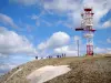
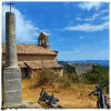
Signal de Lure peak
| Municipality | Lardiers |
|---|---|
| Postcode | 04230 |
| Latitude | 44.0568340 (N 44° 3’ 25”) |
| Longitude | 5.7126150 (E 5° 42’ 45”) |
| Altitude | From 679m to 1700m |
| Surface area | 30.08 km² |
| Population | 135 inhabitants |
| Density | 4 inhabitants/km² |
| Prefecture | Digne-les-Bains (58 km, 59 min) |
| Insee code | 04101 |
| Intercommunality | CC Pays Forcalquier et Montagne de Lure |
| Department | Alpes-de-Haute-Provence |
| Territories | Alps, Provence |
| Region | Provence-Alps-French Riviera |
| L'Hospitalet | 4.6 km (7 min) |
|---|---|
| Ongles | 6 km (9 min) |
| Saumane | 6 km (9 min) |
| Limans | 9.8 km (15 min) |
| La Rochegiron | 10.4 km (17 min) |
| Saint-Étienne-les-Orgues | 11.9 km (18 min) |
| Revest-des-Brousses | 12.7 km (20 min) |
| Banon | 13 km (18 min) |
| Fontienne | 16.8 km (25 min) |
| Cruis | 17 km (23 min) |
| Mane | 17.4 km (24 min) |
| Montsalier | 17.6 km (25 min) |
| Redortiers | 18 km (36 min) |
| Forcalquier | 18.2 km (24 min) |
| Monuments |
|---|
| Last name | Activity type | Rate | City |
|---|---|---|---|
 | Sports sensations | 60 € to 375 € | Saint-Étienne-les-Orgues (5.4 km) |
 | Sports sensations | 15 € to 150 € | Sigonce (12.1 km) |
 | Local flavours | Free | Forcalquier (12.2 km) |
 | Arts and Crafts | 30 € | Saint-Vincent-sur-Jabron (13 km) |
 | Local flavours | Free | Noyers-sur-Jabron (14 km) |
| Last name | Outing type | Difficulty | Duration | Departure municipality |
|---|---|---|---|---|
 | Hike | Athletic | 7:00 | Cruis (9.9 km) |
 | Hike | Easy | 1:00 | Montfroc (12.4 km) |
| Hike | Easy | 2:15 | Mane (14.1 km) |
 | Hike | Easy | 3:20 | Saint-Michel-l'Observatoire (18.6 km) |
 | Hike | Easy | 2:00 | Châteauneuf-Val-Saint-Donat (19.3 km) |