Liven up your holidays!

Landeleau

Tourism, holidays & weekends guide in the Finistère

Landeleau - Tourism, holidays & weekends guide in the Finistère
7.5
5

Common of nearly 1000 inhabitants (landeleausiens), Landeleau is located in the center of western Brittany, halfway between the south and north coasts of Finistère, on the edge of the Aulne, and between the Black Mountains and the Monts Arre.

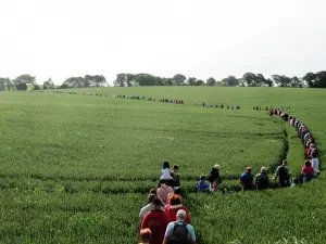
Saint-Théleau (Telo in Breton) came from the sixth century of Wales, gives its name to the town, Lan meaning "place dedicated to a saint". His worship has remained very much alive as attested by the Pardon and Troménie followed every Sunday of Pentecost by many faithful.

Geographical information

MunicipalityLandeleau
Postcode29530
Latitude48.2273790 (N 48° 13’ 39”)
Longitude-3.7297850 (W 3° 43’ 47”)
AltitudeFrom 51m to 183m
Surface area30.41 km²
Population976 inhabitants
Density32 inhabitants/km²
PrefectureQuimper (57 km, 45 min)
Insee code29102
IntercommunalityCC de Haute Cornouaille
DepartmentFinistère
RegionBrittany

Nearest cities & towns

Cléden-Poher6.3 km (9 min)
Spézet6.4 km (11 min)
Plonévez-du-Faou8.3 km (13 min)
Châteauneuf-du-Faou8.9 km (12 min)
Collorec9.1 km (13 min)
Saint-Hernin10.4 km (14 min)
Saint-Goazec10.4 km (16 min)
Plouyé10.8 km (15 min)
Le Cloître-Pleyben14.6 km (22 min)
Gourin15.4 km (19 min)
Lennon16 km (16 min)
Kergloff16 km (15 min)
Roudouallec16.2 km (23 min)

Things to see and do

Events and festivities

Photos

Stang website
Stang website
See photo
Troménie
Troménie
See photo
Stang Festival
Stang Festival
See photo
Stang Festival
Stang Festival
See photo
St Telo Oak
St Telo Oak
See photo
Troménie
Troménie
See photo

Weather

Tuesday 23 april
Min. 5°C - Max. 13°C
Day
Night
Wednesday 24 april
Min. 6°C - Max. 14°C
Day
Night
Thursday 25 april
Min. 4°C - Max. 13°C
Day
Night

Visits, leisure and activities nearby

Outings

Last nameOuting typeDifficultyDurationDeparture municipality
Mountain at Gourin - ​​Circuit 7
HikeIntermediate3:55Gourin (12.8 km)
Variation around the Roscoff-Concarneau Greenway No.7
All-terrain bike itineraryAthletic3:25Gourin (13.5 km)
Roche du Feu hike - Departure from the village
HikeIntermediate1:30Gouézec (19.1 km)
Gouézec circuit from Pont-Coblant
HikeIntermediate3:35Gouézec (19.3 km)
Berrien: Menhir Walking Tour
HikeIntermediate3:20Berrien (19.7 km)

Bed & breakfasts

Vacation rentals

Campsites

Hotels

Your holidays
A hotel
A vacation rental
A bed & breakfast
A campsite
A leisure activity
A restaurant
A rental car
A plane ticket
By continuing to browse our site, you are agreeing to the use of cookies to improve your experience and make targeted offers.
Find out more and make settings
Your account