Laburgade is a commune in the Lot department, in the Occitanie region, 12 km southeast of Cahors.
Its territory of 12.5 km² belongs to the Causse de Limogne, between the Lot valley to the north and the Aveyron plain and valley to the east and south.
This natural region is renowned for its forest areas (truffle oaks), its arid or bare plots but also its lavender fields and its landscapes dedicated to pastoralism. Thus, Laburgade is covered with forests of varying density (57% of its surface area), meadows (28%) and agricultural areas (11%).
Crossed by several rivers (the Tréboulou, the Valses and Cieurac streams), the locality also includes sensitive areas for their biodiversity and is included in the perimeter of the Causses du Quercy Regional Natural Park.
Bordered to the west by the route of the A20 motorway linking Paris to Toulouse, Laburgade is made up of a small originally fortified town (hence its name) and several hamlets and localities.
The activity remains agricultural but tourism is also an area of development, the town being crossed by the GR 65 (Chemin de Saint-Jacques) and benefiting from the proximity of Lalbenque, capital of truffles.
Laburgade which has around 370 inhabitants is worth a detour during a stay in the Lot valley.
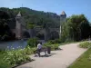
In the heart of the village, several heritage sites deserve attention. A discovery tour can begin with the Saint-Roch church, of Romanesque origin, which has retained a bell tower on the facade. We note that the latter is pierced by a simple bay but, between this and the ogival-shaped portal, a niche houses a beautifully crafted sculpture. The building with its rectangular nave, altered several times and recently restored, reveals itself to be both sober and charming, like the neighboring houses, of Quercy tradition...
More surprising, a few hectometers away, on the route de Cremps, is the “path to the wells”. This is a set of 13 wells built after the Revolution but before 1850 (date on which they are mentioned on the land register). Aligned, with an average depth of three meters, they were made of stone cut from rock and come in a circular or square shape. These wells are fed by resurgences (groundwater which rises to the surface of the ground). Restored in 1988, belonging to different owners, they constitute a real curiosity in their concentration while testifying to what life was like in the 19th century...
The Ourtriols washhouse, south of the town, and the Combe fountain Nègre, which is next to a Calvary, to the southwest, are also worth a look.
Then place the potential available in terms of hiking. It is first of all the GR 65 that should be mentioned: its route follows that of the Via Podiensis, one of the most famous pilgrimage routes to Santiago de Compostela which arrives from Puy and Figeac and then heads towards Cahors, Lauzerte, Moissac… Very busy, its well-maintained route crosses the south of the territory.
However, other trails or small roads allow you to discover the town, its landscapes and its rural heritage by heading towards Lalbenque and its famous truffle market to the south, towards the banks of the Lot less than 10 km to the south. north or towards the Bach phosphate mines to the east…
The opportunity to observe the sensitive areas of the “Pelouses et moors des Serres” or the “vallon de Cieurac”…
Maps and information for hikers at +33 5 65 31 50 08.
Finally, do not hesitate to get information from the Causses du Quercy Regional Natural Park which programs thematic hikes, workshops, exhibitions throughout the year, etc. Contact +33 5 65 24 20 50.