


Putanges-Pont-Ecrépin, together with eight other municipalities, has joined Putanges-Le-Lac, a new municipality since 1 January 2016.
The study of this toponym (name of place), makes us plunge in the history of the commune.
The sedentary peoples who, since the dawn of time, inhabited the region, practicing agriculture and cattle breeding, working on iron, saw the Celts, invaders from the east, about 450 BC. With them was born and flourished the original civilization of Gaul. Civilization which undergoes the imprint of the Romans after the conquests of Caesar. Celtic speech faded before Latin. Then there are the contributions of the German invaders, especially those of the Franks in the Merovingian period, then those of the Scandinavians who occupied, in the tenth century, the present Normandy. In the fifth century, after the victory of Clodius, chief of the Franks, over the Romans, the victors shared the territory of Chenedouit, whence the creation of Meguillaume, Le Sacq, Mesnil Gondouin and Cramesnil.
It is a royal decree, dated January 23, 1822, which created the commune of today by regrouping three villages: Chênedouit, the Meal and Meguillaume.
Considering its relief and its history, Chênedouit is lucky to count on its territory of the listed megaliths: the menhir of the stone raised or right stone (2m50 of height), the table of fairies, dolmen whose orifice d ' Entrance forms a rectangle of 1m30 in height on 0m60 of width and the menhir of the buttes, pyramid quadrangular with rounded summit measuring 1m50. Five calvaries (4 in granite, 1 in wood) were erected on the territory of the commune. There are two churches. The oldest is that of Méguillaume, built in the 15th century, rebuilt in 1742 after a fire, it is dedicated to St. Sebastian. It houses a wooden Christ and a polychrome statuette of the Virgin. The second church was built in the village of Chênedouit in 1841. There is a large altarpiece Louis XIV, a statue of Ste Anne and one of St Wulfram.
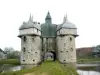
This name is used since 1790 but if we go back a little in time, in 1197, the village was called Foresta Auveredi and thereafter in 1364, La Fôret Aubrée. We must go back to the family of Vassy to find the origin of his name. Philippe de Vassy, who left in crusade in 1096, left his son Enguerrand the rich and beautiful domain of La Forêt-Auvray. He founded a priory near the course of the Orne in the parish of the commune, known as the Chapel or Hermitage of Saint Nicholas, and gave it to the Abbey of Ardennes, founded in 1121. Enguerrand de Vassy left A son named Alfred, Alvered or Auvray, who was said to be of gigantic size, and who was Baron de Vassy and lord of La Forêt, and to whom we owe the name which the commune bears to-day. It remains of the presence of the lords of Vassy, the castle located on the edge of the Orne. From the walls and the castle built in the XVIth century by Louis de Vassy, there remains only the beautiful entrance door that can be admired at the end of the entrance alley of the castle as well as the towers Unfortunately in ruins, the seigniorial lodgings were set on fire for the revolution. Close to the castle, there is a grain mill which is mentioned in the texts from 1125 but the exploitation was stopped in 1875.
In 1982, the halls are restored and the place, repaved, find again the charm that had lost.
The etymology of the Rotors would come from the word "Routoir", which designated in French the place, generally a pond, where the hemp was made to turn red. The ancient form of this word is precisely a rotour or a routour. There is also a place called "Les Chenevières" (hemp fields) as a witness of this period of the tenth century.
According to a register of the fifteenth century, there existed in the parish two distinct fiefs (both dependent on the barony of Louge-sur-Maire): the first is not designated by name, it is the primitive Menil-Jean ; The second, the Papionniere, was the most important, extending around a seigniorial dwelling, on the site of the present castle. He depended successively on the families of Meheudin, La Villette, Fontenai and Beaumais. He came to Les d'Harcourt in the sixteenth century and was sold to Guillaume le Chevalier, squire, whose great-grandson was sentenced to death as a result of criminal adventures (he managed to escape). The brother of the condemned Claude the Chevalier possessed the Menil-Jean and resided there. The successive owners were La Broise, Orglandes, Champagne, Rougé, and Luppé. The Castle is a large square building to which was joined a pretty chapel destroyed since.
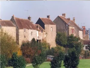
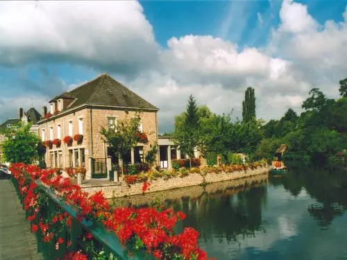
On both sides of the Orne valley, Putanges-Pont-Ecrepin seduces by the charm of its site, the picturesque appearance of the old houses seated on the granite rocks and its famous bell tower overlooking the Orne. These two villages enjoyed prosperity thanks to the iron work at Putanges (forges from 1548 to 1786) and leather work at Pont-Ecrépin.
In 1786, the new purchaser of the Forge destroyed it and transformed the buildings into a mill. In 1900, the Moulin de la Forge was transformed into an electricity generating plant, making the two municipalities the first towns in the Orne to be illuminated with electricity. Since the Middle Ages, Pont-Ecrepin is an active shopping center: chapels, draperies, and especially tanneries which will remain flourishing until the eighteenth century. From this leather industry, the village takes its name "Le Pont Es Crepins". Saint Crepin is indeed the boss of shoemakers.
Its area is 932 hectares for a population of about 170 inhabitants. Until 1650, the fief and the parish of Rabodanges bore the name of Culey sur Orne.
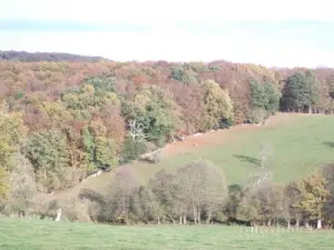
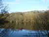
Located between the towns of Falaise, Flers and Argentan, Saint-Aubert-sur-Orne is part of the Swiss Normandy, the river separates it from Rabodanges and part of the lake belongs to it.
The new village is on the plateau, and the Old Saint-Aubert down in the valley, you can see the ruins of the old church and some vestiges.
Sainte-Croix-sur-Orne can boast a long history since its origin goes back to 1150: Sancta Crux, in other words, Sainte-Croix. This name undoubtedly comes from the Cross where Jesus Christ was crucified and which will be sanctified later by the Christian church.

")