Favourite
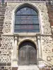
La Ferté-Loupière Church
| Municipality | La Ferté-Loupière |
|---|---|
| Postcode | 89110 |
| Latitude | 47.8974970 (N 47° 53’ 51”) |
| Longitude | 3.2342470 (E 3° 14’ 3”) |
| Altitude | From 132m to 233m |
| Surface area | 30.48 km² |
| Population | 535 inhabitants |
| Density | 17 inhabitants/km² |
| Prefecture | Auxerre (39 km, 31 min) |
| Insee code | 89163 |
| Intercommunality | CC de l'Aillantais en Bourgogne |
| Department | Yonne |
| Territory | Burgundy |
| Region | Burgundy-Franche-Comté |
| Sommecaise | 6.1 km (6 min) |
|---|---|
| Sépeaux-Saint Romain | 7.8 km (30 min) |
| Précy-sur-Vrin | 8.9 km (12 min) |
| Les Ormes | 9.4 km (10 min) |
| Montholon | 11.6 km (17 min) |
| Charny Orée de Puisaye | 11.6 km (19 min) |
| Béon | 12 km (12 min) |
| La Celle-Saint-Cyr | 12.4 km (17 min) |
| Chassy | 12.9 km (20 min) |
| Cudot | 15.1 km (20 min) |
| Senan | 15.4 km (15 min) |
| Saint-Maurice-Thizouaille | 15.4 km (23 min) |
| Villiers-Saint-Benoît | 16.2 km (17 min) |
| Chamvres | 16.9 km (17 min) |
| Monuments |
|---|
| Last name | Activity type | Rate | City |
|---|---|---|---|
 | Sports sensations | 10 € | Joigny (14.5 km) |
| Last name | Outing type | Difficulty | Duration | Departure municipality |
|---|---|---|---|---|
 | Hike | Easy | 2:30 | Lindry (17.4 km) |
 | Hike | Easy | 20 min | Toucy (18.5 km) |
| Village visit | Easy | 3:10 | Migennes (22 km) |
 | Village visit | Easy | 1:30 | Bléneau (31 km) |
 | Hike | Intermediate | 2:15 | Rogny-les-Sept-Écluses (31 km) |