Favourite
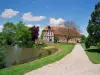
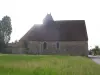
Beaumesnil Castle
| Municipality | Juignettes |
|---|---|
| Postcode | 27250 |
| Latitude | 48.8445660 (N 48° 50’ 40”) |
| Longitude | 0.6536769 (E 0° 39’ 13”) |
| Altitude | From 192m to 251m |
| Surface area | 12.96 km² |
| Population | 225 inhabitants |
| Density | 17 inhabitants/km² |
| Prefecture | Evreux (47 km, 53 min) |
| Insee code | 27359 |
| Intercommunality | CC Interco Normandie Sud Eure |
| Department | Eure |
| Region | Normandy |
| Saint-Antonin-de-Sommaire | 1.7 km (4 min) |
|---|---|
| Les Bottereaux | 3.9 km (9 min) |
| Rugles | 5.1 km (6 min) |
| Ambenay | 7.4 km (10 min) |
| Bois-Arnault | 7.7 km (9 min) |
| Chambord | 8.2 km (10 min) |
| Saint-Martin-d'Écublei | 9.2 km (9 min) |
| Mesnil-Rousset | 9.6 km (9 min) |
| La Haye-Saint-Sylvestre | 10.2 km (12 min) |
| Saint-Nicolas-de-Sommaire | 10.3 km (10 min) |
| Chéronvilliers | 10.8 km (15 min) |
| Saint-Sulpice-sur-Risle | 10.8 km (12 min) |
| Neaufles-Auvergny | 11.1 km (14 min) |
| Last name | Activity type | Rate | City |
|---|---|---|---|
 | Sports sensations | 22 € to 75 € | Fontaine-Simon (46 km) |
 | Local flavours | 55 € | Saint-Philbert-des-Champs (49 km) |
| Last name | Outing type | Difficulty | Duration | Departure municipality |
|---|---|---|---|---|
 | Hike | Easy | 3:00 | Asnières (43 km) |
 | Cycling itinerary | Easy | 4:00 | Montfort-sur-Risle (50 km) |
 | Hike | Easy | 2:50 | Mouettes (52 km) |
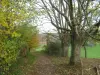 | Hike | Easy | 3:00 | Condé-sur-Risle (52 km) |
 | Hike | Easy | 25 min | Ézy-sur-Eure (57 km) |