


Favourite
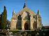
Aulnay-de-Saintonge Church
| Municipality | Gibourne |
|---|---|
| Postcode | 17160 |
| Latitude | 45.9333332 (N 45° 55’ 60”) |
| Longitude | -0.3000007 (W 0° 18’ 0”) |
| Altitude | From 53m to 107m |
| Surface area | 11.00 km² |
| Population | 108 inhabitants |
| Density | 9 inhabitants/km² |
| Prefecture | La Rochelle (88 km, 1:22) |
| Insee code | 17176 |
| Intercommunality | CC Vals de Saintonge Communauté |
| Department | Charente-Maritime |
| Territory | Charentes |
| Region | New-Aquitaine |
| Le Gicq | 4.3 km (6 min) |
|---|---|
| Les Touches-de-Périgny | 5.3 km (9 min) |
| Loiré-sur-Nie | 5.4 km (10 min) |
| Saint-Pierre-de-Juillers | 5.9 km (11 min) |
| Saint-Martin-de-Juillers | 5.9 km (12 min) |
| Bagnizeau | 6.5 km (10 min) |
| Cressé | 7.8 km (14 min) |
| Néré | 8.4 km (11 min) |
| Cherbonnières | 8.4 km (10 min) |
| Seigné | 9.9 km (15 min) |
| Varaize | 10.6 km (17 min) |
| Fontaine-Chalendray | 10.7 km (18 min) |
| Les Éduts | 11 km (18 min) |
| Gourvillette | 11.5 km (17 min) |
| Last name | Activity type | Rate | City |
|---|---|---|---|
 | Sports sensations | 10 € to 20 € | Saint-Bris-des-Bois (22 km) |
 | Local flavours | Free | Graves-Saint-Amant (36 km) |
 | Local flavours | Free | La Couronne (46 km) |
| Last name | Outing type | Difficulty | Duration | Departure municipality |
|---|---|---|---|---|
 | Hike | Easy | 1:00 | Mons (24 km) |
 | Hike | Easy | 3:45 | Puyrolland (30 km) |
 | Hike | Easy | 1:05 | Saintes (33 km) |
 | Hike | Easy | 4:05 | Saintes (34 km) |
| Village visit | Easy | 1:00 | Le Gua (55 km) |