Favourite
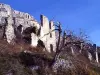
Entrevaux
| Municipality | Gars |
|---|---|
| Postcode | 06850 |
| Tourism label | ") |
| Latitude | 43.8654040 (N 43° 51’ 55”) |
| Longitude | 6.8032130 (E 6° 48’ 12”) |
| Altitude | From 640m to 1649m |
| Surface area | 15.57 km² |
| Population | 74 inhabitants |
| Density | 4 inhabitants/km² |
| Prefecture | Nice (82 km, 1:29) |
| Insee code | 06063 |
| Intercommunality | CA du Pays de Grasse |
| Department | Alpes-Maritimes |
| Territories | Alps, French Riviera |
| Region | Provence-Alps-French Riviera |
| Amirat | 6 km (12 min) |
|---|---|
| Les Mujouls | 8.1 km (13 min) |
| Collongues | 8.6 km (13 min) |
| Briançonnet | 9.2 km (15 min) |
| Sallagriffon | 12.8 km (19 min) |
| Val-de-Chalvagne | 17 km (25 min) |
| Saint-Auban | 17.2 km (28 min) |
| Saint-Pierre | 19.3 km (28 min) |
| Saint-Antonin | 21 km (32 min) |
| La Penne | 21 km (30 min) |
| Sigale | 21 km (31 min) |
| Soleilhas | 24 km (36 min) |
| La Rochette | 24 km (35 min) |
| Entrevaux | 25 km (39 min) |
| Ubraye | 27 km (39 min) |
| Last name | Activity type | Rate | City |
|---|---|---|---|
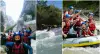 | Sports sensations | 35 € | Puget-Théniers (12.5 km) |
 | Sports sensations | 55 € | Gréolières (13.7 km) |
 | Sports sensations | 90 € to 130 € | Gréolières (13.9 km) |
 | Sports sensations | 45 € | Gourdon (21 km) |
 | Sports sensations | 55 € | Gourdon (21 km) |
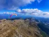
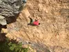
| Last name | Outing type | Difficulty | Duration | Departure municipality |
|---|---|---|---|---|
 | Hike | Intermediate | 3:30 | Thorenc (6.7 km) |
 | Hike | Athletic | 5:00 | Gréolières (13.7 km) |
 | Hike | Easy | 2:45 | Gréolières (13.7 km) |
 | Village visit | Easy | 1:30 | Gréolières (13.7 km) |
 | Hike | Easy | 2:30 | Annot (15.7 km) |