Favourite
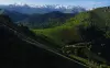
The Aubisque Pass
| Municipality | Ferrières |
|---|---|
| Postcode | 65560 |
| Latitude | 43.0107560 (N 43° 0’ 39”) |
| Longitude | -0.2629380 (W 0° 15’ 47”) |
| Altitude | From 453m to 1848m |
| Surface area | 16.97 km² |
| Population | 82 inhabitants |
| Density | 4 inhabitants/km² |
| Prefecture | Tarbes (54 km, 1:05) |
| Insee code | 65176 |
| Intercommunality | CC Pays de Nay |
| Department | Hautes-Pyrénées |
| Territories | Gascony, Midi-Pyrénées, Pyrenees |
| Region | Occitanie |
| Arbéost | 3.3 km (5 min) |
|---|---|
| Arthez-d'Asson | 10.5 km (13 min) |
| Asson | 16.5 km (20 min) |
| Arrens-Marsous | 21 km (32 min) |
| Bruges-Capbis-Mifaget | 22 km (25 min) |
| Lestelle-Bétharram | 22 km (29 min) |
| Aucun | 23 km (35 min) |
| Montaut | 24 km (28 min) |
| Gaillagos | 26 km (40 min) |
| Arcizans-Dessus | 26 km (39 min) |
| Bun | 26 km (39 min) |
| Saint-Pé-de-Bigorre | 28 km (33 min) |
| Arras-en-Lavedan | 28 km (40 min) |
| Sireix | 31 km (48 min) |
| Last name | Activity type | Rate | City |
|---|---|---|---|
 | Culture and education | 16 € | Saint-Pé-de-Bigorre (11.9 km) |
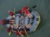 | Sports sensations | 32 € to 57 € | Lestelle-Bétharram (14 km) |
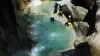 | Sports sensations | 45 € to 70 € | Castet (14.1 km) |
 | Sports sensations | 40 € to 210 € | Argelès-Gazost (14.4 km) |
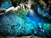 | Sports sensations | 50 € to 75 € | Beaucens (16.8 km) |
| Last name | Outing type | Difficulty | Duration | Departure municipality |
|---|---|---|---|---|
 | Hike | Athletic | 2:00 | Ferrières |
 | Hike | Easy | 50 min | Arbéost (4.2 km) |
 | Hike | Easy | 1:55 | Arrens-Marsous (5.5 km) |
 | Village visit | Easy | 1:00 | Gaillagos (7.2 km) |
 | Hike | Intermediate | 2:15 | Béost (7.3 km) |