Favourite
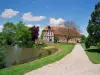
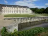
Champ de Bataille Castle
| Municipality | Écardenville-la-Campagne |
|---|---|
| Postcode | 27170 |
| Latitude | 49.1189700 (N 49° 7’ 8”) |
| Longitude | 0.8470110 (E 0° 50’ 49”) |
| Altitude | From 139m to 159m |
| Surface area | 7.40 km² |
| Population | 477 inhabitants |
| Density | 64 inhabitants/km² |
| Prefecture | Evreux (26 km, 29 min) |
| Insee code | 27210 |
| Intercommunality | CC Intercom Bernay Terres de Normandie |
| Department | Eure |
| Region | Normandy |
| Bray | 1.6 km (3 min) |
|---|---|
| Rouge-Perriers | 3.9 km (8 min) |
| Épreville-près-le-Neubourg | 3.9 km (5 min) |
| Villez-sur-le-Neubourg | 4.5 km (10 min) |
| Sainte-Opportune-du-Bosc | 5.4 km (9 min) |
| Le Neubourg | 5.5 km (7 min) |
| Le Plessis-Sainte-Opportune | 5.7 km (15 min) |
| Thibouville | 6.2 km (8 min) |
| Goupil-Othon | 6.6 km (7 min) |
| Le Tremblay-Omonville | 7.5 km (8 min) |
| Beaumont-le-Roger | 7.7 km (8 min) |
| Sainte-Colombe-la-Commanderie | 7.8 km (9 min) |
| Combon | 8.2 km (10 min) |
| Last name | Activity type | Rate | City |
|---|---|---|---|
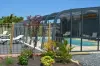
 | Entertainment | 40 € | Sotteville-lès-Rouen (38 km) |
 | Local flavours | 55 € | Saint-Philbert-des-Champs (42 km) |
| Last name | Outing type | Difficulty | Duration | Departure municipality |
|---|---|---|---|---|
 | Cycling itinerary | Easy | 4:00 | Montfort-sur-Risle (24 km) |
 | Hike | Intermediate | 1:10 | Orival (26 km) |
 | Hike | Easy | 35 min | Orival (26 km) |
 | Cycling itinerary | Athletic | 2:05 | La Bouille (26 km) |
 | Hike | Intermediate | 1:55 | Orival (27 km) |