


Favourite
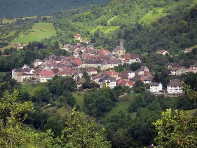
The Joux castle
| Municipality | Dommartin |
|---|---|
| Postcode | 25300 |
| Latitude | 46.9234820 (N 46° 55’ 25”) |
| Longitude | 6.3079219 (E 6° 18’ 29”) |
| Altitude | From 807m to 944m |
| Surface area | 6.39 km² |
| Population | 781 inhabitants |
| Density | 122 inhabitants/km² |
| Prefecture | Besançon (58 km, 49 min) |
| Insee code | 25201 |
| Intercommunality | CC du Grand Pontarlier |
| Department | Doubs |
| Territories | Franche-Comté, Jura mountains |
| Region | Burgundy-Franche-Comté |
| Houtaud | 1.3 km (4 min) |
|---|---|
| Vuillecin | 2.3 km (6 min) |
| Chaffois | 3.9 km (8 min) |
| Doubs | 4.7 km (6 min) |
| Sombacour | 6.1 km (9 min) |
| Pontarlier | 6.7 km (12 min) |
| Bulle | 7.9 km (8 min) |
| Bians-les-Usiers | 8 km (11 min) |
| Bannans | 8.8 km (10 min) |
| Arçon | 9.3 km (12 min) |
| Granges-Narboz | 9.5 km (14 min) |
| Goux-les-Usiers | 9.7 km (14 min) |
| La Cluse-et-Mijoux | 11.1 km (16 min) |
| La Rivière-Drugeon | 11.1 km (13 min) |
| Last name | Activity type | Rate | City |
|---|---|---|---|
 | Sports sensations | 50 € | Foncine-le-Bas (38 km) |
 | Sports sensations | 38 € | Chapelle-des-Bois (39 km) |
 | Entertainment | 84 € to 110 € | Besançon (41 km) |
| Last name | Outing type | Difficulty | Duration | Departure municipality |
|---|---|---|---|---|
 | Hike | Easy | 1:05 | La Rivière-Drugeon (9.6 km) |
 | Hike | Intermediate | 35 min | Hauterive-la-Fresse (12.9 km) |
 | Hike | Easy | 3:00 | Arbois (41 km) |
| Hike | Easy | 1:00 | Lac-des-Rouges-Truites (42 km) |
| Hike | Athletic | 3:30 | Bellefontaine (45 km) |


