Darnac:
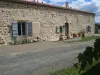
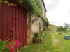
The castle of the Coast in Chapt.
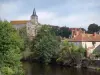
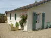
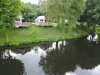
Castle Purcy.
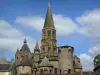
The church in the town center.
Fountain St John the Baptist.
| Municipality | Val-d'Oire-et-Gartempe |
|---|---|
| Postcode | 87320 |
| Latitude | 46.2342990 (N 46° 14’ 3”) |
| Longitude | 0.9061480 (E 0° 54’ 22”) |
| Altitude | From 122m to 267m |
| Surface area | 121.46 km² |
| Population | 1690 inhabitants |
| Density | 13 inhabitants/km² |
| Prefecture | Limoges (85 km, 1:04) |
| Insee code | 87028 |
| Intercommunality | CC Haut Limousin en Marche |
| Department | Haute-Vienne |
| Territory | Limousin |
| Region | New-Aquitaine |
| Saint-Bonnet-de-Bellac | 8.8 km (8 min) |
|---|---|
| Saint-Martial-sur-Isop | 9.2 km (13 min) |
| Adriers | 11.1 km (12 min) |
| Saint-Sornin-la-Marche | 11.8 km (14 min) |
| Oradour-Saint-Genest | 12.6 km (13 min) |
| La Croix-sur-Gartempe | 12.9 km (17 min) |
| Moulismes | 13.1 km (12 min) |
| Asnières-sur-Blour | 13.2 km (18 min) |
| Plaisance | 13.2 km (15 min) |
| Lathus-Saint-Rémy | 14 km (18 min) |
| Mouterre-sur-Blourde | 14.9 km (22 min) |
| Luchapt | 15.1 km (20 min) |
| Le Dorat | 15.2 km (13 min) |
| Gajoubert | 17.5 km (25 min) |
The castle of the Coast in Chapt.
Castle Purcy.
The church in the town center.
Fountain St John the Baptist.
| Monuments | |
|---|---|
| Natural sites |
| Last name | Outing type | Difficulty | Duration | Departure municipality |
|---|---|---|---|---|
 | Hike | Easy | 3:35 | Lathus-Saint-Rémy (7.6 km) |
 | Hike | Intermediate | 3:55 | Mouterre-sur-Blourde (12.5 km) |
 | Cycling itinerary | Easy | 1:45 | Saulgé (16.2 km) |
 | Car itinerary | Easy | 1:15 | L'Isle-Jourdain (16.9 km) |
 | Hike | Intermediate | 2:00 | L'Isle-Jourdain (16.9 km) |