Liven up your holidays!

Dampierre-les-Bois

Tourism, holidays & weekends guide in the Doubs

Dampierre-les-Bois - Tourism, holidays & weekends guide in the Doubs
7.8
1

Geographical information

MunicipalityDampierre-les-Bois
Postcode25490
Latitude47.5062960 (N 47° 30’ 23”)
Longitude6.9125040 (E 6° 54’ 45”)
AltitudeFrom 335m to 420m
Surface area4.72 km²
Population1609 inhabitants
Density340 inhabitants/km²
PrefectureBesançon (89 km, 1:08)
Insee code25190
IntercommunalityCA Pays de Montbéliard Agglomération
DepartmentDoubs
TerritoriesFranche-Comté, Jura mountains
RegionBurgundy-Franche-Comté

Nearest cities & towns

Fesches-le-Châtel2.4 km (5 min)
Badevel2.9 km (4 min)
Beaucourt3.3 km (6 min)
Fêche-l'Église3.5 km (4 min)
Méziré3.5 km (8 min)
Dasle4 km (7 min)
Étupes4.4 km (6 min)
Allenjoie4.6 km (9 min)
Morvillars5.3 km (8 min)
Vandoncourt5.6 km (9 min)
Montbouton5.7 km (11 min)
Taillecourt5.8 km (8 min)
Exincourt6.9 km (9 min)
Brognard7.2 km (10 min)

Events and festivities

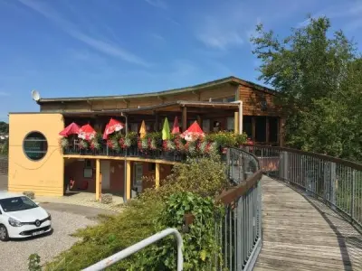
Atelier 123 Nature : La Fresque du Climat

Photos

Fontaine, at the northern entrance of the village (© J.E)
See photo
Great street Dampierre-les-Bois (© J.E)
See photo
Dampierre-les-Bois, seen from the street of the temple (© J.E)
See photo
Great street Dampierre-les-Bois (© J.E)
See photo
St. Peter's Church, view from the temple (© J.E)
See photo
Temple seen from the church (© J.E)
See photo
Mayor of Dampierre-les-Bois (© J.E)
See photo
Arms of the city (© Jean Espirat)
See photo
Fountain at the cherub (© Jean Espirat)
See photo
St. Peter's Church (© J.E)
See photo
church facade St. Peter (© J.E)
See photo
Fountain, near the town hall (© J.E)
See photo
Temple seen from the central square (© J.E)
See photo
Temple (© J.E)
Temple (© J.E)
See photo

Weather

Friday 19 april
Min. 0°C - Max. 7°C
Day
Night
Saturday 20 april
Min. 1°C - Max. 6°C
Day
Night
Sunday 21 april
Min. 1°C - Max. 6°C
Day
Night

Visits, leisure and activities nearby

Leisure activities

Last nameActivity typeRateCity
Visit a copper mine
Culture and education11 € Le Thillot (43 km)

Outings

Last nameOuting typeDifficultyDurationDeparture municipality
Walk to Fort Lachaux- Grand-Charmont, Sochaux, Montbéliard
HikeIntermediate35 minGrand-Charmont (6.9 km)
Tour of the historic centre
Village visitEasy1:00Masevaux-Niederbruck (30 km)
Rangen massif
HikeIntermediate1:00Burnhaupt-le-Haut (30 km)
Sattelboden Chalet
HikeIntermediate3:00Masevaux-Niederbruck (31 km)
Lachtelweiher Lake
HikeIntermediate2:30Kirchberg (33 km)

Restaurants

Bed & breakfasts

Vacation rentals

Campsites

Hotels

Your holidays
A hotel
A vacation rental
A bed & breakfast
A campsite
A leisure activity
A restaurant
A rental car
A plane ticket
By continuing to browse our site, you are agreeing to the use of cookies to improve your experience and make targeted offers.
Find out more and make settings
Your account